Zonation
One of the most striking features of any rocky shore anywhere in
the world at low tide is the prominent horizontal banding or zonation of the organisms. Each zone or band is
set off from those adjacent by differences in color, morphology of the major
organism, or some combination of color and morphology. These horizontal bands
or zones succeed each other vertically as one progresses
up from the level of the lowest low tides to true terrestrial conditions
(Figures 6.7, 6.8). This zonation on intertidal rocky shores is similar to the zonation pattern one observes with increasing elevation on
a mountain, where the different horizontal zones of trees and shrubs succeed
each other vertically until, if one progresses far enough, permanent snow cover
is reached. The major difference between these two areas is the scale.
Mountain zones are perhaps kilometers in extent as opposed to intertidal zones extending a few meters vertically.
Rocky intertidal
zones vary in vertical extent, depending on the slope of the rocky surface, the
tidal range, and the exposure to wave action. Where there is a gradual slope to
the rock, individual zones may be broad. Under similar tidal and exposure
conditions on a vertical face, the same zones would be narrow. In the same
manner, exposed areas have broader zones than protected shores, and shores
with greater tidal ranges have broader vertical zones (Figures 6.4, 6.8).
Of course, these striking bands
may be interrupted or altered in various places wherever the rock substrate
shows changes in slope, composition, or irregularities that change its
exposure or position relative to the prevailing water movement.
The fact that these prominent
zones can be observed on nearly all rocky shores throughout the world under
many different tidal regimes led Stephenson and Stephenson (1949) to propose,
after some 30 years of study, a "universal" scheme of zonation for rocky shores (Figure 6.9). This universal
scheme was really a framework using common terms that would allow comparison
of diverse areas. It established zones based on the distributional limits of
certain common groups of organisms and not on tides. It reflects the knowledge
of the Stephensons, and other intertidal
ecologists, that distribution patterns of the organisms and zones vary not only
with tides, but with slopes and exposure. Therefore, under similar tidal
conditions there could be different bandwidths due to different exposures or
slopes of rocks. It was this universal scheme that established a standard
format for describing shore zonation, replacing a
bewildering host of schemes and names established by earlier biologists.
The Stephensons'
scheme has three main divisions of the intertidal
area. The uppermost is termed the supralittoral fringe.
Its lower limit is the upper limit of barn4eles, and it extends to the
upper limit of snails of the genus Littorina (periwinkles).
The dominant organisms are the littorine snails and
black encrusting lichens (Verrucaria type). The extreme high water of spring
tides reaches part of this zone, but most of its water comes from wave splash.
Above this zone is the terrestrial or supralittoral
zone.
The middle
part of the intertidal is termed the midlittoral zone and is the broadest in extent.
Its upper limit coincides with the upper limit of barnacles, while its lower
limit is the point where zone is often subdivided and contains a host of
different organisms. Perhaps the only universally present dominant group are the barnacles.
The lowest zone of this scheme
is the infralittoral fringe, which extends from the lowest
low tide up to the upper limit of the large kelps. This is an extremely rich
zone composed of organisms that can tolerate only limited exposure to air. It
is really an intertidal extension of the infralittoral zone (Stephensons'
term) or what we know as the sublittoral area.
Although Stephensons'
scheme did set forth a means for describing zonation
on rocky shores, it does not offer an explanation of why the zonation occurs. It is this explanation of zonal patterns
that intrigues many marine biologists.
Causes of Zonation
Whereas it is fairly easy to recognize and measure the extent of
the zones on a rocky shore, it is more difficult to find suitable explanations
for why organisms are distributed in these zones. Physical and biological
factors can be considered to explain the phenomenon. We shall take up each in
turn.
Upper-limit barnacles
Equinoctial high-water spring tides
,aria
is
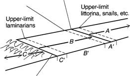 A = Supralittoral (spray) zone A' = Supralittoral fringe
B = Littoral zone
B' = Midlittoral
C = Infralittoral zone C = Infralittoral fringe
FIGURE 6.9 Stephensons'
universal scheme of zonation for rocky shores. (From R. L. Smith, Ecology and field biology, 3d ed., Figure 8-4.
Copyright © 1980 by Robert
Leo Smith. Reprinted by permission of Harper & Row Publishers, Inc.)
large kelps (Laminaria, etc.) reach their uppermost
distribution. This
nalus is
Rocky
Shores Reading
- How
do rocky shores compare with sand and mud shores?
- What
types of animals dominant the intertidal rocks?
- What
types of animals dominant the subtidal rocks?
- What
is the most striking feature of any rocky shore?
- How
is one zone different from another?
- Compare
and contrast rocky shores with mountains?
- What
are 3 ways rocky intertidal zones vary?
a)
b)
c)
- What
conditions may alter the bands or zones?
- In
the Stephenson’s scheme, there are three main divisions. What are they?
10 Describe each zone discussed in question 9