TIDES;
any of the cyclic
deformations of one astronomical body caused by the gravitational forces
exerted by others. The most familiar are the periodic variations in sea level
on the Earth that
correspond to changes in the relative positions of the Moon and
the Sun; the daily fluctuation of elevation of the water surfaces of oceans and
seas and the larger lakes of the world.
Tide-generating forces: The forces that cause the tides are called
the tide-generating forces. A tide-generating force is the resultant force of
the attracting force of the Moon or the Sun and the force of inertia
(centrifugal force) that results from the orbital movement of the Earth around
the common center of gravity of the Earth-Moon or Earth-Sun system.
At the surface of the Earth the gravitational
force of the Moon is about 2.2 times greater than that of the Sun. The
tide-producing action of the Moon arises from the variations in its
gravitational field over the surface of the Earth as compared with its strength
at the Earth's center. The effect is that the water tends to accumulate on the
parts of the Earth's surface directly toward and directly opposite the Moon and
to be depleted elsewhere. The regions of accumulation move over the surface as
the position of the Moon varies relative to the Earth, mainly because of the
Earth's rotation but also because of the Moon's orbital motion around the
Earth. There are approximately two high and two low tides per day at any given
place, but they occur at times that change from day to day; the average
interval between consecutive high tides is 12 hours 25 minutes. The effect of
the Sun is similar and additive to that of the Moon. Consequently, the tides of
largest range or amplitude
(spring tides) occur at New Moon, when the Moon and the Sun are
in the same direction, and at Full Moon, when they are in opposite directions;
the tides of smallest range (neap tides)
occur at intermediate phases of the Moon.
Although
the observed tides possess the aforementioned broad features, this pattern does
not correspond to a pair of bulges that move around the Earth. The inertia of
the water, the existence of continents, and effects associated with the water
depth result in much more complicated behavior.
For the main oceans, a combination of theory and observation
indicates the existence of amphidromic points, at which the tidal rise and fall
is zero: patterns of high and low tides rotate around these points (either
clockwise or counterclockwise). Amplitudes are typically less than a meter. Tides are most easily observed--and of
greatest practical importance--along seacoasts, where the amplitudes are
exaggerated. When tidal motions run into the shallow waters of the continental
shelf, their rate of advance is reduced, energy accumulates in a smaller volume,
and the rise and fall is amplified. The details of tidal motions in coastal
waters, particularly in channels, gulfs, and estuaries, depend on the details
of coastal geometry and water-depth variation. Tidal amplitudes, the contrast
between spring and neap tides, and the variation of times of high and low tide
all vary widely from place to place.
For these
reasons, purely theoretical calculation of the times and heights of tides at a
particular station is quite impossible. Nevertheless, tides are quite successfully
predicted on the basis of accumulated observations of the tides at the place concerned. The analysis of the observations relies on the
fact that any tidal pattern (in time) is a superposition of variations
associated with periodicities in the motions of the Moon and the Sun relative
to the Earth. The periods involved are the same everywhere, ranging from about
12 hours to a year or more, but the relative sizes of their contributions are
highly variable. Observations over a sufficient time make it possible to
calculate which contributions are significant at a particular location and,
thus, to forecast tidal times and heights. It is common that 40 components may
be significant for practical calculations at one location.
In addition to tides in the oceans (and in large
lakes, where similar processes occur with smaller amplitudes), there are
analogous gravitational effects on the atmosphere and on the interior of the
Earth. Atmospheric tides are detectable
meteorological phenomena but are a comparatively minor component in atmospheric
motions. An Earth tide (q.v.) differs
from oceanic and atmospheric ones in that the response to it is an elastic
deformation rather than a flow. Observations of Earth tides contribute to
knowledge of the internal structure of the Earth.
Tidal processes can, of course, also occur on
other members of the solar system. As just one example, it has been suggested
that the volcanic activity of Jupiter's satellite Io is the consequence of internal
heating by frictional resistance to tidal deformation.
In contrast to the tides of the
At certain places in the South Pacific the natural
period of oscillation of the sea accentuates the solar tidal oscillation. At these locations
the time of the AM (or PM) high (or low) water, instead of getting later each
day by about 50 minutes (as is generally the case), occurs at approximately the
same time for several days in succession. The tide at
In general, tidal ranges within the Pacific are
small. That at Tahiti is about one foot; at
Considering the Earth- Moon system, at any time the
tide-generating force is directed vertically upward at the two places on the
Earth where the Moon is in the vertical (on the same and on the opposite side
of the Earth); it is directed vertically downward at all places (forming a
circle) where the Moon is in the horizon at that moment. At all other places,
the tide-generating force also has a horizontal component. Because this pattern
of forces is coupled to the position of the Moon with respect to the Earth and
because for any place on the Earth's surface the relative position of the Moon
with respect to that place has, on the average, a periodicity of 24 hours 50
minutes, the tide-generating force felt at any place has that same periodicity.
When the Moon is in the plane of the equator, the force runs through two
identical cycles within this time interval because of the symmetry of the
global pattern of forces described above. Consequently, the tidal period is 12
hours 25 minutes in this case; it is the period of the semidiurnal lunar tide. The fact that
the Moon is alternately to the north and to the south of the equator causes an
inequality of the two successive cycles within the time interval of 24 hours 50
minutes. The effect of this inequality is formally described as the
superposition of a partial tide called the diurnal lunar tide, with the period of
24 hours 50 minutes, on the semidiurnal lunar tide.
In the same
manner, the Sun causes a semidiurnal solar tide, with a 12-hour period, and a
diurnal solar tide, with a 24-hour period. In a complete description of the
local variations of the tidal forces, still other partial tides play a role
because of further inequalities in the orbital motions of the Moon and the
Earth. The interference of the solar-tidal forces with the lunar-tidal forces
(the lunar forces are about 2.2 times as strong) causes the regular variation
of the tidal range between
spring tide, when it has its maximum, and neap tide, when it has its minimum.
Although the tide-generating forces are very small
in comparison with the Earth's force of gravity (the lunar tidal force at its
maximum being only 1.14 [{times}] 10{sup -7} times the force of gravity), their
effects upon the sea are considerable because of their horizontal component.
Since the Earth is not surrounded by an uninterrupted envelope of water but
rather shows a very irregular alternation of sea and land, the mechanism of the
response of the oceans and seas to the tidal forces is extremely complex. A
further complication is caused by the deflecting force of the Earth's rotation
(the Coriolis force; see above).
In
enclosures formed by gulfs and bays,
the local tide is generated by interaction with the tides of the adjacent open
ocean. Such a tide often takes the form of a running tidal wave that rotates
within the confines of the enclosure. In some semi-enclosed seas, such as the
In these seas, the tidal range of sea level is
only on the order of centimeters. In the open ocean, it generally is on the
order of tens of centimeters. In bays and adjacent seas, however, the tidal
range may be much greater, because the shape of a bay or adjacent sea may favor
the enhancement of the tide inside; in particular, there may be a resonance of
the basin concerned with the tide. The largest known tides occur in the Bay
of Fundy, where spring tidal ranges up
to 15 meters have been measured.
3. TIDES;
any of the cyclic
deformations of one astronomical body caused by the gravitational forces
exerted by others. The most familiar are the periodic variations in sea level
on the Earth that
correspond to changes in the relative positions of the Moon and
the Sun; the daily fluctuation of elevation of the water surfaces of oceans and
seas and the larger lakes of the world.
Tide-generating forces: The forces that cause the tides are called
the tide-generating forces. A tide-generating force is the resultant force of
the attracting force of the Moon or the Sun and the force of inertia
(centrifugal force) that results from the orbital movement of the Earth around
the common center of gravity of the Earth-Moon or Earth-Sun system.
At the surface of the Earth the gravitational
force of the Moon is about 2.2 times greater than that of the Sun. The
tide-producing action of the Moon arises from the variations in its
gravitational field over the surface of the Earth as compared with its strength
at the Earth's center. The effect is that the water tends to accumulate on the
parts of the Earth's surface directly toward and directly opposite the Moon and
to be depleted elsewhere. The regions of accumulation move over the surface as
the position of the Moon varies relative to the Earth, mainly because of the
Earth's rotation but also because of the Moon's orbital motion around the
Earth. There are approximately two high and two low tides per day at any given
place, but they occur at times that change from day to day; the average
interval between consecutive high tides is 12 hours 25 minutes. The effect of
the Sun is similar and additive to that of the Moon. Consequently, the tides of
largest range or amplitude
(spring tides) occur at New Moon, when the Moon and the Sun are
in the same direction, and at Full Moon, when they are in opposite directions;
the tides of smallest range (neap tides)
occur at intermediate phases of the Moon.
Although
the observed tides possess the aforementioned broad features, this pattern does
not correspond to a pair of bulges that move around the Earth. The inertia of
the water, the existence of continents, and effects associated with the water
depth result in much more complicated behavior.
For the main oceans, a combination of theory and
observation indicates the existence of amphidromic points, at which the tidal
rise and fall is zero: patterns of high and low tides rotate around these
points (either clockwise or counterclockwise). Amplitudes are typically less
than a meter. Tides are most easily
observed--and of greatest practical importance--along seacoasts, where the
amplitudes are exaggerated. When tidal motions run into the shallow waters of
the continental shelf, their rate of advance is reduced, energy accumulates in
a smaller volume, and the rise and fall is amplified. The details of tidal
motions in coastal waters, particularly in channels, gulfs, and estuaries, depend
on the details of coastal geometry and water-depth variation. Tidal amplitudes,
the contrast between spring and neap tides, and the variation of times of high
and low tide all vary widely from place to place.
For these
reasons, purely theoretical calculation of the times and heights of tides at a
particular station is quite impossible. Nevertheless, tides are quite
successfully predicted on the basis of accumulated observations of the tides at
the place concerned. The analysis of the observations relies on the fact that
any tidal pattern (in time) is a superposition of variations associated with
periodicities in the motions of the Moon and the Sun relative to the Earth. The
periods involved are the same everywhere, ranging from about 12 hours to a year
or more, but the relative sizes of their contributions are highly variable.
Observations over a sufficient time make it possible to calculate which
contributions are significant at a particular location and, thus, to forecast
tidal times and heights. It is common that 40 components may be significant for
practical calculations at one location.
In addition to tides in the oceans (and in large
lakes, where similar processes occur with smaller amplitudes), there are
analogous gravitational effects on the atmosphere and on the interior of the
Earth. Atmospheric tides are detectable
meteorological phenomena but are a comparatively minor component in atmospheric
motions. An Earth tide (q.v.) differs
from oceanic and atmospheric ones in that the response to it is an elastic
deformation rather than a flow. Observations of Earth tides contribute to
knowledge of the internal structure of the Earth.
Tidal processes can, of course, also occur on
other members of the solar system. As just one example, it has been suggested
that the volcanic activity of Jupiter's satellite Io is the consequence of internal
heating by frictional resistance to tidal deformation.
In contrast to the tides of the
At certain places in the South Pacific the natural
period of oscillation of the sea accentuates the solar tidal oscillation. At these locations
the time of the AM (or PM) high (or low) water, instead of getting later each
day by about 50 minutes (as is generally the case), occurs at approximately the
same time for several days in succession. The tide at
In general, tidal ranges within the Pacific are
small. That at Tahiti is about one foot; at
Considering the Earth- Moon system, at any time the
tide-generating force is directed vertically upward at the two places on the
Earth where the Moon is in the vertical (on the same and on the opposite side
of the Earth); it is directed vertically downward at all places (forming a
circle) where the Moon is in the horizon at that moment. At all other places,
the tide-generating force also has a horizontal component. Because this pattern
of forces is coupled to the position of the Moon with respect to the Earth and
because for any place on the Earth's surface the relative position of the Moon
with respect to that place has, on the average, a periodicity of 24 hours 50
minutes, the tide-generating force felt at any place has that same periodicity.
When the Moon is in the plane of the equator, the force runs through two
identical cycles within this time interval because of the symmetry of the
global pattern of forces described above. Consequently, the tidal period is 12
hours 25 minutes in this case; it is the period of the semidiurnal lunar tide. The fact that
the Moon is alternately to the north and to the south of the equator causes an
inequality of the two successive cycles within the time interval of 24 hours 50
minutes. The effect of this inequality is formally described as the
superposition of a partial tide called the diurnal lunar tide, with the period of
24 hours 50 minutes, on the semidiurnal lunar tide.
In the same
manner, the Sun causes a semidiurnal solar tide, with a 12-hour period, and a diurnal
solar tide, with a 24-hour period. In a complete description of the local
variations of the tidal forces, still other partial tides play a role because
of further inequalities in the orbital motions of the Moon and the Earth. The
interference of the solar-tidal forces with the lunar-tidal forces (the lunar
forces are about 2.2 times as strong) causes the regular variation of the tidal
range between spring
tide, when it has its maximum, and neap
tide, when it has its minimum.
Although the tide-generating forces are very small
in comparison with the Earth's force of gravity (the lunar tidal force at its
maximum being only 1.14 [{times}] 10{sup -7} times the force of gravity), their
effects upon the sea are considerable because of their horizontal component.
Since the Earth is not surrounded by an uninterrupted envelope of water but
rather shows a very irregular alternation of sea and land, the mechanism of the
response of the oceans and seas to the tidal forces is extremely complex. A
further complication is caused by the deflecting force of the Earth's rotation
(the Coriolis force; see above).
In
enclosures formed by gulfs and bays,
the local tide is generated by interaction with the tides of the adjacent open
ocean. Such a tide often takes the form of a running tidal wave that rotates
within the confines of the enclosure. In some semi-enclosed seas, such as the
In these seas, the tidal range of sea level is
only on the order of centimeters. In the open ocean, it generally is on the
order of tens of centimeters. In bays and adjacent seas, however, the tidal
range may be much greater, because the shape of a bay or adjacent sea may favor
the enhancement of the tide inside; in particular, there may be a resonance of
the basin concerned with the tide. The largest known tides occur in the Bay
of Fundy, where spring tidal ranges up
to 15 meters have been measured.
4-Understanding
tides
The
tide is the periodic daily or semidaily fluctuation of the sea surface. Ocean
tides occur worldwide, but the degree of fluctuation varies from imperceptible to many
meters. The first documented reference
to tides was in the fifth century B.C. by the Greek historian, Herodotus, who
observed characteristics of the tide in the
As
human horizons expanded, knowledge of physical sciences and, thus,
understanding of tides also increased. From the first, tides have been
considered important to navigation. Knowledge of tides was essential for growth
and development of coastal communities that flourished as a result of early
commerce. Wharves, buildings, and other structures had to be constructed with
the ever-changing watr level in mind (figure 1).
Today, it is even more
important that complicated but rhythmic tidal motions and their associated
forces be understood as we build closer to the waterfront or shore. Bridges and
pipelines connect points of land once considered inaccessible. Bays and harbors
have to be protected from the forces of the sea, of which the tide is a major
contributor. Supertankers, no longer able to enter many existing ports, have to
be handled on the continental shelf, requiring deepwater loading facilities in
exposed areas. Consequently, we need to understand not only tides in coastal
areas, but also those of the open ocean.
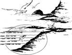 fig 2
fig 2
Figure
2.-The height of the ocean's surface
rises and falls with predictable regularity. The means of these periodic high-
and low-water conditions are defined as tidal datums. The tidal datums are
relative (that is, related to one another) and identified as shown above.
As
people seek to better manage the wastes they dump into streams, rivers, and
estuaries, they are calling on oceanographers for more information concerning
estuarine and coastal circulation. This is essential for establishing
intelligent but practical waste management procedures. Tides play an important
role in determining rates of dilution, mixing, and flushing of these coastal waters.
Defining
seaward boundaries is another issue with relevance for tide knowledge. In the
offshore oil industry, for example, state-Federal boundaries must be precisely
defined for determining which jurisdiction may claim taxable revenue.
Similarly, as in past years along the
To help keep track of
these mean tide elevations and use them, certain standard references have been
established. The most effective references are the tidal datums, which are simply fixed references from which we
reckon heights or depths. There are a variety of such datums, called by
different names, such as mean low water,
mean lower low water, mean high water, mean higher high water, and mean sea level.
Each of these tidal datums may be determined in
relation to a time period of a specified length, called a tidal epoch. These tidal datums can be located on the ground and mapped .
2 Elementary tidal theory the equilibrium tide
The
cause-and-effect relationship between the Moon and tides remained a mystery
until 1687, when Isaac Newton published his classic book, Philosophiae naturalis principia mathematica, which stated his laws
of gravity..
The
Moon as primary force. Although a number of forces act to produce
tides, for the moment we will consider only the forces caused by the Moon.
On
the side of the Earth nearer the Moon, the gravitational attraction between the
Earth and the Moon is greater than the centrifugal force. On the side of the
Earth farther from the Moon, the centrifugal force is greater than the
gravitational attraction between Earth and Moon.
Thus, the tide-generating forces try to
create two tidal "bulges" on opposite sides of the Earth along a line
connecting the Earth's center and the Moon's center..
Because there are two bulges,, there are generally two
tides per lunar day (figure 3).
The Sun as secondary tidal force.
Heavenly bodies other than the Moon cause tide-generating forces, but the only
other body of significance is the Sun. Although it has far greater mass than
the Moon, the Sun is much farther from the Earth than the Moon. Consequently,
the Sun's tide-generating force on Earth is only about 46 percent as great as
that of the Moon. ,
To
understand the variations in tides as they occur over extended periods of time,
consider the constantly changing relationship of'the Earth, the Moon, and the
Sun. Remember that the Moon orbits about the rotating Earth, and both the Earth
and the Moon orbit about the Sun. In addition, remember that they do' so not in
perfect circles, but in ellipses, so that distances one from the other are
constantly-and predictably changing.
Remember that the Earth's axis is tilted
with respect to its orbit about the Sun, and the Moon's orbit is also at an
angle to the Earth's orbit. Therefore, the angular relationships between the
Earth and the Moon, and the Earth and the Sun, are constantly-and predictably changing.
Now let's look at the effects of all these dynamic relationships.
 Figure 3.-Two
tidal "bulges" are present on opposite sides of the Earth, formed by
the difference between the gravitational forces and the centrifugal force
caused by the Earth's revolution around the center of mass of the Earth-Moon
system. The Earth makes one complete rotation relative to the moon every 24
hours and 50 minutes. Thus, a location on a coast moves through each of the
ocean bulges in a lunar day, and there are two tides a day along most coasts.
Figure 3.-Two
tidal "bulges" are present on opposite sides of the Earth, formed by
the difference between the gravitational forces and the centrifugal force
caused by the Earth's revolution around the center of mass of the Earth-Moon
system. The Earth makes one complete rotation relative to the moon every 24
hours and 50 minutes. Thus, a location on a coast moves through each of the
ocean bulges in a lunar day, and there are two tides a day along most coasts.
The
Moon and the Sun interact. Anyone who has observed tides or studied a tide
table has noted that the difference between a high tide and a low tide may be
greater at one time of the month than at another. The range of tide, or difference between successive high and low
waters, varies primarily as a result of the changing positions of the Sun and
Moon with respect to the Earth.
Figure
4 reminds us that as the Moon rotates about the Earth approximately once a month, it is aligned with the Sun twice a month and it is at
right angles (quadrature) at two
other times during the month.
When the Moon is on a
line connecting the Earth and the Sun, we have either a new Moon or a full
Moon. At this time the attractive forces of the Sun and the Moon are aligned
and reinforce each other, increasing the tidal bulge. When this occurs
semimonthly, the range is increased, with the high tides being higher and low
tides being lower than average. These are called spring tides (this name implies no reference to the season of the
year).
When the Moon is at quadrature, we have
either a first-quarter or a third-quarter Moon. At this time the attractive
forces of the Sun and the Moon are at right angles and tend to counteract one
another, resulting in a decreased tidal range. .high tides are lower and low
tides are higher than average. These are called neap tides.
![]()
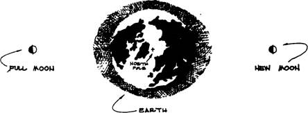
Figure 4a.-During times of full and new Moon, the
Earth, Sun, and Moon are in a line; and spring tides occur.
![]()
Figure 4b.-When the Moon is at first and third
quarter, the Moon and Sun form a right angle with the Earth; neap tides now
occur.
Effects of elliptical orbits.
As the Moon moves through its elliptical orbit about the Earth approximately
once each month, it passes through points nearest and farthest from the Earth.
Figure 5 illustrates this phenomenon. The point nearest the Earth is called perigee; that farthest from the Earth, apogee. Tide range is increased when the
Moon passes through perigee. The tide range is decreased at apogee.
As the Earth moves about
the Sun, a similar situation occurs. The point when the Earth is nearest the
Sun is perihelion; farthest from the
Sun, aphelion. The effect of the
Earth's passing through perihelion and aphelion is less pronounced than the
counterparts of the Moon's motion but is of the same sort. And, of course, it
occurs on a yearly basis instead of monthly.
The
angular relationship. As noted previously, we observe a changing
angular relationship between the Earth and the Moon, and the Earth and the Sun.
The angular distance north or south of the equator is called declination. The changing declination of
the Moon and the Sun also play an important role in modifying tides.
The
Moon's declination completes a full cycle approximately every 27 1/3 days. In
completing this cycle, it can reach maximum values of nearly 28.60 north and south of the equator.
As
the Moon approaches its maximum declination (once north and once south each
cycle), its attractive force is unevenly distributed with respect to the
equator, as shown in figure 8. The effect is to cause a difference in the
heights of succeeding high waters and succeeding low waters in the same day.
The difference between high waters and between low waters is known as diurnal inequality (diurnal means
"daily").
Diurnal
inequality is generally at a maximum when maximum declination occurs, producing
what are called tropic tides. Diurnal
inequality is at a minimum when the Moon is over the equator, causing equatorial tides. As one would expect,
tropic and equatorial tides each occur twice every cycle of 271/3 days.
Interaction. Of course, all of these
astronomic movements go on
simultaneously in cycles whose lengths vary one from the other. Thus, their
combined effects may be to enhance or nullify one another. In a later section,
we will note how all combine to affect clamming tides in
The real tide varies
from theory.
In discussing
equilibrium theory, we assumed the Earth was a smooth surface completely
covered by a fluid in equilibrium with the tide generating forces. We ignored
the effects of friction in the movement of fluid, inertia, depth of the ocean,
presence of continents, and rotation of the Earth. Of course, all of these factors
must be considered when we study the tides as they really are. If equilibrium
assumptions were valid, tidal response would be simultaneous with the
tide-producing forces.
Because
this is not the case, the time of high tide varies considerably throughout the
world's oceans in relation
to
when the Moon passes over the local meridian. (A meridian is a great circle of
the Earth passing through the poles and any given point on the Earth's
surface.) The height of tide also cannot be explained entirely by the simplified
theory. Consequently, equilibrium theory does not fully account for the
observed tidal phenomena. Instead it only gives us insight into the basic
causes and fluctuations.
Predicting tides. When we deal with
nature, one of our prime objectives is to predict future events. Tides are no
exception. In predicting the behavior of the ocean, we generally can predict
tides better than any other natural phenomenon, at least in coastal areas where
knowledge of the tides is most essential.
Our ability to predict tides is good not
because we understand the theory of tides better than that of other oceanic
events, but because the tide is determined by the Sun and Moon, movements of
which are well-ordered in time and space.
The
marigram, or graphic record of the
rise and fall of the tide, at a given location, is a continuous function that
is periodic, readily lending itself to a curve-fitting procedure and thus a
forecast of tidal heights.
Types of tide
A marigram is
distinctive for a specific location, but there are general characteristics of
the ties throughout the world that permit us to establish a classification
system. Figure 7 shows examples of marigrams for diurnal, semidiurnal, and mixed
types.
Diurnal. A
tide is diurnal if, during the period of a lunar day (of 24 hours and 50
minutes), there occurs only one high water and one low water. Diurnal tides are
primarily caused by the changing declination of the Moon and are most
pronounced at the times of maximum declination (figure 6). These tides are
found in the northern
Semidiurnal.
The semidiurnal tide is that which is most commonly found throughout the world.
It is characterized by two high waters and two low waters in the lunar day. The
elevations of succeeding high waters and succeeding low waters are nearly the
same. A semidiurnal tide is found on the East Coast of the
Mixed.
Just as with a semidiurnal tide, the mixed tide is marked by two high waters
and two low waters in a lunar dav. Succeeding high
waters, low waters, or both are generally different in height, however. These
differences are known as diurnal inequality. Remember the inequality is caused
by the changing declination of the Moon. Mixed tides are common to the West
Coast of the continental
Phenomena associated with tides
Marigrams
may show changes in water level that are not due solely to tidal movement
caused by heavenly bodies. A nong these tidal phenomena are meteorological effects. Also, in any
discussion of tides the related horizontal movement of water, or tidal
currents, should be mentioned.
The meteorological effects.
Water responds to external forces applied to it. Two forces always at work in
varying degrees on the water surface are wind and direct barometric pressure.
They combine to effect a change in the elevation of the water surface known as
wind setup or storm surge.
In coastal areas where
the water is shallow, wind interacts with water at the surface and as a result
moves the water from one area to another. It is not easy to say exactly how a water body will respond because the
effects are determined by wind speed, duration, and distance over which the wind blows (fetch), as well as by such other
complicating factors as topography and stage of the tide.
It
is generally true in coastal areas, however, that the water surface will
respond directly to the wind. Thus, a wind blowing toward shore will tend
to
raise the water level on the coast and wind blowing away from shore, to decrease
it.
As barometric pressure
increases, the elevation of the surface of the water tends to be depressed and,
conversely, as the pressure decreases, the elevation tends to be increased. As
with wind, the amount of displacement is difficult to predict and depends on
the intensity of the barometric disturbance and the speed with which it moves,
in addition to the characteristics of the body of water.
The meteorological
effects are particularly noticeable with the passage of large storms such as
hurricanes. Strong winds and low pressure can raise the water level along a
coast considerably. If this resultant storm surge is superimposed on an
unusually high tide, occurring normally at that time, extreme flooding is often
the result.
To
some extent, the meteorological effects are predictable with change of seasons
and can be estimated for predicting water level. Random disturbances raise
havoc in predicting water level, however. If the astronomic tide is small, then
random meteorological disturbances often represent a significant portion of the
total change in water level-making accurate predictions extremely difficult.
Tide predictions
generally do not include provisions for the contributions to the change in
water level for other than the astronomic tide. In some cases, however, the
seasonal fluctuations are included. Thus, when actual water level does not
agree with predicted tide elevations, it is not the result of poor
tide predictions, but rather the influence of
random meteorological effects.
Seiches. A seiche
(pronounced SAYsh) is a stationary wave oscillation the period of which
depends on the dimensions of the local semienclosed body of water. You create a
simple miniature seiche when you tilt a rectangular dishpan of water. The
maximum change in water elevation occurs at the ends of the pan while no change
in water level occurs in the middle. Figure 8 shows the oscillations of a
seiche with ape period of about an
hour imposed on the tidal fluctuation at
A
seiche is generated by an external force, often one of the same forces that
generate a storm surge. After the force has been removed, the body of water
responds by oscillating at its natural frequency.
As the period of the seiche approaches that
of the tide, it is possible that the range of the tide can be considerably
affected. Some of the great tidal ranges in the world can be attributed to this
interaction of the tide of the open ocean and the seiche of a semienclosed body
of water. For example, the mean range of tide at Burntcoat Head, which is in
the Minas basin of the
Tidal
currents. Oceanographers usually define current as a horizontal flow of water. A tidal current is a horizontal flow of
water generated by the tide-producing forces .
Tidal currents, like the
tides themselves, are periodic, and they can be analyzed and predicted. Tides,
as one-dimensional phenomena, are easy to monitor. Tidal currents, on the other
hand, are more complicated because they are two-dimensional (speed and
direction). There are some cases, however, in which the movement of the waters
is confined to one dimension, so the direction of flow reverses as the water
flows alternately toward (flood current) and
away from (ebb current) the land.
Taking
a look at tides along the
What kind of tides does
The
average difference in the elevation of the two low waters each day is 0.67
meter. The average difference in the elevation of the two high waters each day
is only 0.43 meter. Thus, the low water inequality is about 1.5 times larger
than the high water inequality for the
What is the range o f tides
in
When
do tides occur in
When do
As a consequence of the
greater diurnal inequality and high sea level, the highest predicted tide
usually occurs during December or January. Often winter storms further raise
the water level above the normal winter high tides, resulting in local
flooding.
|
Location |
Mean range (meters) |
|
(N. jetty) |
1.70 |
|
|
1.80 |
|
Barview |
1.74 |
|
Taft |
1.52 |
|
|
1.80 |
|
Waldport |
1.77 |
|
|
1.55 |
|
|
1.58 |
|
Bandon |
1.58 |
|
Port Orford |
1.61 |
|
Brookings |
1.55 |
Table
1.-Mean range of tide at selected tides
locations along the
The lowest tides of the year generally occur in
summer as a result of the increased inequality in the low waters combined with
the lowered sea level.
Why are good clam tides in the evening in
December and in the morning in June? This is a result of the
concurrence of extreme astronomical phenomena:
In
December
-when there is a full
Moon, resulting in spring tides,
-the Moon is near north
declination, increasing diurnal inequality.
In June
-when there is a new
Moon, resulting in spring tides,
-the Moon is near north
declination, increasing diurnal inequality.
The
times of the lows are related to the
passage of the Moon over the
How
do tides vary in the estuaries?
The time and range of tide in the estuaries vary considerably
from the time and range of tide along the coast. Each estuary has its own
individual characteristics. In the case of the
Fundy’s Tremendous Tides
An incredible one hundred
billion tons of briny water swirl their way up the shores of the
At the bay's eastern
extremity spectators have seen the highest tides ever recorded anywhere. The
tide there has been measured at 16 m (52 1/2 ft), the equivalent height of a
four-story building or nearly the distance from a pitcher's mound to home
plate. And that's not the distance traveled up the beach- it is the height the
water has risen!
These tides not only
have left their indelible mark on the people who inhabit Fundy coastal and
island communities but also reveal the geological history of the awesome power
manifested in forming the region. Down the eons of time they have battered the cliffs of Grand Marian, sculpted the flowerpot rocks at
On its swift way to
shore the tide climbs the barnacle crusted legs of wooden wharves along the
jagged perimeter of the bay. It
swells tiny creeks and submerges reefs, sandbars, beaches and mud flats on its
way to program the regular arrival of the Tidal Bore in the
And to show off a rather
distorted sense of humor, twice each day the tides charge the mouth of the
mighty
At
Along
the bay where there are rocks and cliffs in place of sloping beaches, a very
different kind of sea life is revealed when the tide recedes. Instead of the
constantly scoured, soft sand or mud where creatures can burrow but plants
cannot cling, layers of rock are gradually exposed
showing the varied sea life that
thrives at different water levels and leaving protected, calm tidal pools that
are replenished twice daily.
WHY
ARE THE FUNDY TIDES SO HIGH?
HOW Do THEY WORK?
Fundy
tides are the highest in the world because of the shape and dimensions of the
bay.
When
the tidewater enters the
The
length of the bay is another reason the Fundy
tides are so high. When the low or ebb tide runs out of the bay it collides
with the new, incoming high tide combining forces to make an even higher wave coming in. The combination of
wave forces is called resonance. The length and depth of the basin determine
its particular rhythm. e water of the Bay of Fundy
rocks from one end to the other in time with the water in the
The
mechanics of tides is complex, but it's the pull of the moon that does most of
the work. Sometimes the sun ves a hand when the moon and sun
are in phase, or lineup, with the
earth. This occurs about twice a month, once at the new moon again when
the moon is full. The resulting tides are some 20 per cent higher than normal.
These are called spring tides not for the season of the year but simply meaning
`when waters spring up from the sea!" When the pull of the sun and moon are
at right angles to the earth during the first and third quarters of the moon,
the tides are lower and are called neap from the Anglo-Saxon word meaning
sparse or scanty.
The
sea and its tides have always played a major role in the development of
The
constant, forceful motion of the water is instrumental in providing enough
food for the amazing range of birds, fish and marine mammals that make the bay
at least a temporary home. Whether raising nutrients from the deep, uncovering
feeding grounds or increasing the hunting
area, the richness of the supply keeps nature's circle of small devoured by larger rolling horn microscopic organism to whale size.
The
Bay of Fundy is an important stop on
the route of countless migratory birds because it can supply them with enough food - some birds double their weight at this
provision stop - to fuel them for the long Journey that may be as far as the
Arctic or
Dulse,
pronounced to rhyme with pulse, is an edible seaweed,
a nutritious and tasty product harvested during low tide when its reddish color
can be seen above the water line. Experienced pickers find the best, leanest,
long-stranded dulse between the rocks rather than on top. It is then dried in
the sun so that its crisp saltiness
provides a tang of the sea in all seasons. Most of North America's duke comes
from
Herring
fishing along the
There
have been a number of off-again schemes to utilize the tide of Fundy. A young
engineer Cooper, a native of
A
These
ingenious men weren't the first to seriously consider tidal energy. A mill
partially powered by tidal force was
built under the instruction of Sicur de Poutrincourt at Port Royal in 1609,
five years after Champlain
established
The
closest New Brunswick has ever come to witnessing a commercial-scale Fundy
tidal power reality was in the mid1930s when under the Quoddy Plan, authorized
by executive order of U.S. President Roosevelt, a two-dam system in Passamaquoddy
Bay near Eastport, Maine, was started.
While mankind presses its apprehensive face against the window-pane of tomorrow, the
flowing treasure known as the tides of Fundy continues moving in a mighty swell
in and out, back and forth, in an eternal rhythm orchestrated by the moon.
Marine Science Reading Program 4 Name__________________________________________pd______
11.
Tide readings Name……………………………..pd……..
1. What is a tide?
2. What
is a tide generating force
3. How much stronger is the gravitational force
of the moon on the earth than the sun on the earth?
4. What is the average interval between tides?
5. What is a
amphidromic point?
6. How does shallow water effect tides?
7. How are tides predicted?
8.
Where do diurnal tides occur?
9. How are tides in the South Pacific different
from other world tides?
10. Why
is there an inequality of two successive tidal cycles?
11. What is a tidal seiche?
12. What is a cause that effects
the range of tides?
12 Understanding Tides
1. Name 2 people that documented
tides and the places they observed these.
2. Give 3 reasons knowledge of tides is important today.
3. What is meant by the term tidal datum?
4. Who was responsible for the formation of the equilibrium theory of tides and
when?
5. Explain how the moon affects the tides on earth.
6. What force is the sun on tides compared to that of the moon?? Why is it
different?
7. What is meant by the range of the tide and what causes the differences?
8. What is responsible for spring tides? Neap tides?
9. Explain perigee and apogee…how do these affect tides?
10. Explain perihelion and aphelion…how often do these occur?
11. How long does the moon take to complete its declination cycle? How far
north/south of the equator does it travel?
12. When is diurnal inequality at its Maximum? Minimum?
13. Why does the real tide vary from theory?
14. What factors allows tide prediction to be accurate?
15. Explain the 3 types of tides.
16. What are some meteorological effects on tides and explain how each happens.
17. When actual water level does not agree with the predicted tide elevations,
what went wrong?
18. Describe
a seiche.
19. What causes a tidal current?
20. What is meant by the terms flood and ebb?
21. What kind of tides does
22. What is the tidal range in
23. What is meant by the solstice and what effect does it have on tides?
24. Explain why there are good clam tides in the evening in December and in the
morning in June?
25. Do tide times vary in estuaries?