1 The Case Of The Disappearing Shoreline
Humans change the earth's climate in many ways. One change is
the increase of carbon dioxide in the atmosphere. As we burn more fossil fuels,
we release more and more carbon dioxide into the atmosphere. Most scientists
think that, over time, this will change the earth's atmosphere. Some say it
will make the earth become warmer; others think it will make the earth become
cooler. In either case, small temperature changes can have large effects on the
earth's geography. For example, if the average annual temperature increases,
more ice and snow at the poles will melt. This would cause a rise in ocean
levels all around the world. Some coastal cities might be flooded.
In this activity, imagine that larger amounts of carbon
dioxide will cause a warming trend in the atmosphere. You will study the
effects such a change might have on the
Procedure
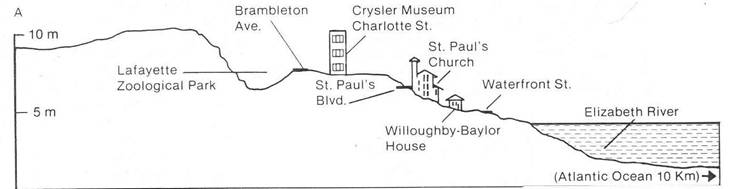
1. Assume that each 0.1 °C rise in the earth's a. 0.1 degree C
annual temperature, will cause the sea level to b. 0.2
degree C rise by 1.0 m. Diagram A shows a cross-section c. 0.4 degree C of
2.
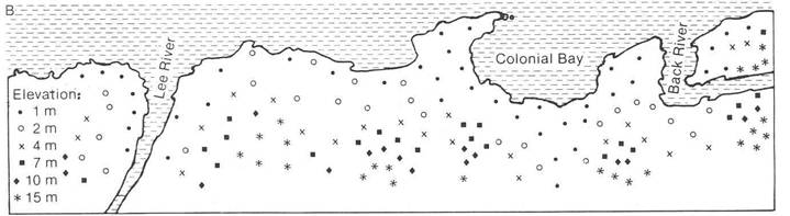
Suppose Diagram B shows part of the southeastern shoreline. The elevation of a
number of points is given. Draw what you think the new shoreline would look
like if the annual average temperature rose by each of the amounts given in
step 1. For each temperature rise, use a different color.
Analysis
1. List problems that might occur
along the southeastern coast if the earth's annual temperature rose by 0.2
degrees C.
2. Suppose the prediction we used above is wrong and
increasing amounts of carbon dioxide cause the earth's annual temperature to go
down. This would cause the polar ice caps to grow. How would that change your
shorelines on Diagrams A and B?
3. What advantages and
disadvantages are there if the earth's average temperature increases by 0.4°C?
Answer this (a) for people living near the shore and
(b) for people living 200 km inland.
2 Beaches, Sand, and Currents
The
The most common mineral in sandy beaches is quartz, which
comes from inland on the continent. Rock fragments are eroded away by rivers
and carried down to the ocean. When these pieces of rock reach the ocean, they
are pounded into tiny grains by the movement of waves against the shore. Other
sources of materials for sand are rock outcroppings along the shore and the
shells of marine animals. Along the coast of
Some of the
most beautiful and valued beaches in this region are on barrier islands. These
are islands of sand built up by the ocean and parallel to the mainland. Barrier
islands are formed along gently sloping sandy coasts where the water remains
shallow far from the shore. Their name comes from the fact that these stretches
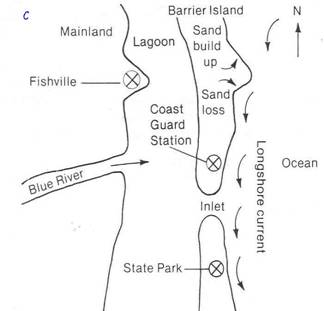
of sand are between the ocean and the mainland. Figure C shows barrier islands,
the lagoon behind, their inlets, and a river that empties into the lagoon.
Once formed, barrier islands are far from permanent. Giant
winter storms with their huge waves can form new inlets or close older ones.
During these storms, large amounts of sand can be dug from one place and
deposited elsewhere along the beach. Even during the calmer weather of summer,
the ever-present surf is constantly reshaping the islands. Breaking waves carry
sand with them as they run back into the sea. Longshore
currents pick up this sand and move it down the coast. Since the longshore currents in this area usually move southward,
they are slowly carrying the barrier islands in that direction. Where there is
an arm of land into the ocean or an inlet, sand is deposited on the north side
and eroded away on the south side. This constant migration of sand can cause
entire sections of beach to disappear or the mouths of inlets to move as much
as 25 meters a year.
Because
barrier islands are such splendid areas, many people want to live and work on
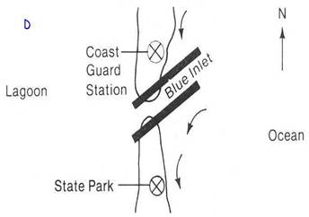
them. To do so, they try to change the island to fit their needs. Figure D
shows how the people who live in Fishville plan to
change Blue Inlet. They want to stop the migration of the inlet by putting in
jetties, or walls, along the inlet. Should this plan be carried out? Look at
the diagrams and the information, then answer the
questions below.
1.
How does the
2. Why do you think people at Fishville are concerned about the movement of Blue Inlet?
3. If you were the State Park
Director how would you react to the plan? Why?
4. If you
were in charge of the Coast Guard Station how would you
react to the plan? Why?