Current
I
Ocean Notes Frictional forces.
Movement of water through the oceans is slowed by
friction, with surrounding fluid moving at a different velocity. A
faster-moving fluid layer tends to drag along a slower-moving layer, and a
slower-moving layer will tend to reduce the speed of a faster-moving layer.
This momentum transfer between the layers is referred to as frictional forces.
The momentum transfer is a product of turbulence
that moves kinetic energy to smaller scales until at the centimetre
scale it is dissipated as heat. The wind blowing over the sea surface
transfers momentum to the water. This frictional force at the sea surface
(i.e., the wind stress) produces the wind-driven circulation. Currents moving
along the ocean floor and the sides of the ocean also are subject to the
influence of boundary-layer
friction. The motionless ocean floor removes momentum from the circulation of
the ocean waters.
Ekman layer.
The wind exerts stress on the ocean surface
proportional to the square of the wind speed and in the direction of the wind,
setting the surface water in motion. This motion extends to a depth of about
100 metres in what is called the Ekman
layer, after the Swedish oceanographer V. Walfrid Ekman, who in 1902 deduced these results in a theoretical model
constructed to help explain observations of wind drift in the
Since the wind varies from place to place, so does
the Ekman transport, forming convergence and divergence zones of surface
water. A region of convergence forces surface water downward in a process
called downwelling, while a region of divergence
draws water from below into the surface Ekman layer
in a process known as
upwelling. Upwelling and downwelling
also occur where the wind blows parallel to a coastline. The principal
upwelling regions of the world are along the eastern boundary of the
subtropical ocean waters, as, for example, the coastal region of
Surface water is less dense than deeper water. Ekman convergences have the effect of accumulating less
dense surface water. This water floats above the surrounding water, forming a
hill in sea level and driving an nticyclonic geostrophic current that extends well below the Ekman layer. Divergences do the opposite; they remove the
less dense surface water, replacing it with denser, deeper water. This induces
a depression in sea level with a cyclonic geostrophic
current.
The ocean current pattern produced by the
wind-induced Ekman transport is called the Sverdrup
transport, after the Norwegian oceanographer H.U. Sverdrup, who formulated the
basic theory in 1947. Several years later (1950), the
American geophysicist and oceanographer Walter H. Munk and others
expanded Sverdrup's work, explaining many of the major features of the
wind-driven general circulation by using the mean climatological
wind stress distribution at the sea surface as a driving force.
Thermocline,
Oceanic water layer in which water
temperature decreases rapidly with increasing depth.
A widespread permanent thermocline exists beneath the
relatively warm, well-mixed surface layer, from depths of about 200 m (660
feet) to about 1,000 m (3,000 feet), in which interval temperatures diminish
steadily. The deep waters below the thermocline layer
decrease in temperature much more gradually toward the seafloor. In latitudes
marked by distinct seasons, a seasonal thermocline at
much shallower depths forms during the summer as a
result of solar heating, and it is destroyed by diminished insolation
and increased surface turbulence during the winter. Water density is governed
by temperature and salinity; consequently, the thermocline
coincides generally with the
pycnocline, or layer in which density
increases rapidly with depth. The middle layer of water in a lake or reservoir
during the summer is also called a thermocline. Copyright
(c) 1995 Encyclopaedia Britannica, Inc. All Rights
Reserved
II Upwelling
As the wind blows from
land out to sea, or even alongshore (parallel to the coastline), it can push
coastal surface water further out to sea. Deeper waters move up to replace the
"missing " surface water. This is called
upwelling. Upwelling can also occur in the open ocean away from land where
surface currents move away from each other, pulling deeper water up to fill the
void.
Upwelling brings colder and often more
nutrient-rich waters up to the surface of the ocean. This process can
dramatically affect the temperature of both the surface ocean and an adjacent
land mass, as well as enhancing biological productivity of the ocean. Influx of
nutrients enhances growth of tiny marine plants called phytoplankton, which are
eaten by other marine organisms. Upwelling areas are good places to go
fishing!
Penguin Note: Estimates put fisheries
catches from upwelling areas at around 50% of the total, although these
areas make up only about 1% of the
surface area of the ocean!
It's easy to see how wind blowing across the
sea surface causes horizontal water motion. But how can it end up causing
vertical movement in deeper waters? We have the revolution of Earth around its
axis to thank! Wind-driven transport of water offshore can be aided by the Coriolis effect. Here's a quick
summary of the Coriolis effect: the centrifugal force
set up by Earth's rotation always acts to deflect moving bodies to the right of
their original path in the Northern Hemisphere and to the left in the Southern
Hemisphere (a fuller explanation is given in GLACIER's
Coriolis effect section). So even when the wind is
blowing parallel to the coastline, the movement of surface water will be
deflected to the right (left) in the Northern Hemisphere (Southern
Hemisphere).
Eastern boundary current areas (along the west
coast of continents) are good places to look for upwelling. Major coastal upwelling
regions include the California-Oregon coast, the west coasts of South America,
Africa, and
When the wind blows parallel to a Northern
Hemisphere coastline and the ocean is to the right of the wind direction,
upwelling can result. What happens when the ocean is to the left? Surface
waters, influenced by wind and the Coriolis effect, are driven toward the coast. These waters pile up.
Because of the wind, the water cannot go back horizontally, so they go downward
instead. This vertical flow of water to a deeper level is called downwelling. This process carries oxygen to deeper levels
in the ocean system, replenishing its supply to oxygen-dependent
organisms.
One example of upwelling occurs along the

Illustration of upwelling and downwelling (modified from Garrison,
III MESSAGE IN A BOTTLE: BY STUDYING OBJECTS CAST UP ON OUR SHORES, RESEARCHER CURTIS EBBESMEYER
TRACES THE FLOW OF OCEAN CURRENTS
IF CURTIS EBBESMEYER HAD JUST
ONE WORD FOR BUDDING oceanographers, it would probably be: plastics. If he had
more than one, he might add: roll-on antiperspirant balls, toxic-waste
containers, computer monitors, lightbulbs, armadas of
toys and sporting goods, toilet seats, bales of rubber and marijuana, explosive
devices, surfboards, coconuts, aircraft, the occasional human body, and a
surprising number of genuine messages in bottles. The seas are wonderfully,
horribly full of floating things. Sooner or later, many of them wash up on the
beach; and on the way, some make epic continent-to-continent journeys, thus
forming new data points regarding the complex doings of long-distance ocean
current systems—the subject of Ebbesmeyer’s work.
Scientists study currents ever more intensely: they affect
not only transportation but weather, biology, evolution and climate change.
Most oceanographers use satellites and high-tech buoys for tracking them; Ebbesmeyer, a self-described “filter feeder on floating objects,” stubbornly does it the old-fashioned way—by studying movements of random junk. Part reporter and
historian, part water physicist, he has sources everywhere, including his own
vast, ragtag worldwide army of beachcombers. “The literature of things that float from here to there is so scattered it
makes no sense until you compress it,” he says. “Then it begins to take on a glow, like
radium.”
His contributions to the literature range from the seminal
to the semi-wacky, but we know one thing: he is probably the only scientist to
have posed for People magazine mostly naked (grayed in the
chest hairs, but looking good) in the pool with a floating bathtub ducky, a
souvenir of one of his greatest research triumphs. Colleagues with fancier
instruments and stiffer attitudes may sneer, but deep down they must suspect
the truth: he has more fun than they do. Along the way, he has learned that ocean
surface currents can be chaotically changeable; if two bathtub toys are dumped,
say, in the middle of the Pacific at the same moment in the same spot, one may
wash up in Hawaii while the other might end up frozen in an Arctic ice floe.
I accidentally entered the world of long-distance floatables on a Canadian Coast Guard icebreaker traversing
the Northwest Passage—that frozen labyrinth of islands where
Arctic ice floes slowly drain toward the
Ebbesmeyer got started in the mid-1960s with Mobil
Oil as a roustabout, then, after attending the
Each ocean, carrying the long-distance floatables
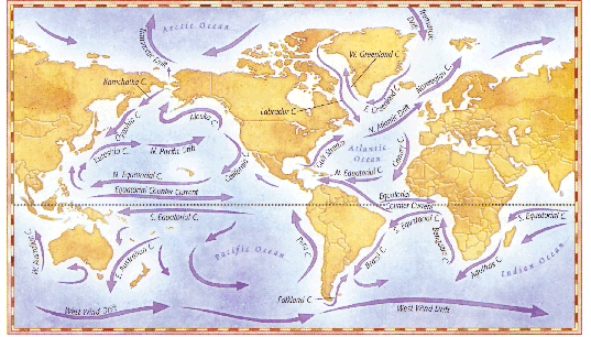
studied by Ebbesmeyer, hosts one or more huge gyres
shaped by prevailing winds, Earth’s rotation and bordering landmasses. The Gulf Stream, skirting the U.S.
East Coast, is part of a clockwise pattern of surface currents that carries
Caribbean debris past Nantucket, toward
Unless sidetracked in any of countless ways. Storms drive
floaters off track, especially ones with windage—exposed surface area making a sail—into countercurrents or competing gyres, like the North
Pacific’s counterclockwise Alaska Current, which
can snag something from the Pacific Northwest and send it towards Siberia, or
filter it through the teeth of the Aleutians to be sucked through the Bering
Strait and into the swirling belly of the Arctic. Alternatively, junk may hang
out for years if it drifts into the eyes of the great oceanic gyres. Also, strong
winds can cause water masses to upwell or downwell powerfully, which is reflected both in surface
movements and in huge worldwide submarine currents that flow their own separate
ways—a whole other story.
It is also becoming apparent that major surface current
systems, once thought stable as rocks, are capable of huge, sudden shifts. In
the prehistoric past, these could have been the result—or cause—of drastic climate change; many scientists think that cycle could recur,
with dire results. Oceanic distributions of nutrients depend on currents;
hitchhiking on currents is integral to the life cycles of everything from eels
to sharks. There’s also evidence that even large
terrestrial animals may spread and evolve by the unlikely mechanism of “rafting” on ocean debris.
It seems unlikely also that any small human-made object
can survive a long voyage, make it to a beach and stay long enough for someone
to come along at just the right moment to discover it. But objects do. Boy, do
they.
In 1959, the Guinness brewing company of
Ebbesmeyer loves such arcana,
but must admit that his first love is garbage. There is so much of it. And most
is plastic. The buoyant, indestructible stuff has exploded since the 1950s and ’60s; before that most marine garbage was organic, so it
eventually rotted or sank. The bulk may come from land, dumped offshore or
floated out rivers, but ships contribute much. Lost synthetic fishing gear
alone—nets, traps, buoys, lines, packing
material—may run 150,000 tons a year. More is
washed or thrown off merchant and pleasure vessels, despite a 1987
international convention supposedly curbing marine dumping. As many as 1,000 or
more boxcar-size shipping containers—perhaps the most fruitful sources of intriguing objects—fall off ships annually, releasing fleets of floatable
goods.
The results are horrifying. In some years tens of
thousands of seals and hundreds of thousands of seabirds may die entangled in
lost fishing gear. Turtles, whales, fish and at least 100 seabird species
mistake plastics for floating food: autopsied animals are often crammed with
cigarette lighters, plastic bags, tampon applicators, toy soldiers. Old
plastics break up under ultraviolet radiation and waves, but never die; they
turn into “nurdles”—colorful, anonymous fingernail- to BB-size bits. The ocean
keeps trying to cleanse itself of them like a cold
sufferer spitting phlegm. After a recent count, the Southern California Coastal
Water Research Project estimated there were more than one million per mile
along
Others have long put floatables
to work for science. Eighteenth- and nineteenth-century explorers figured out
the outlines of major currents simply by watching where objects traveled,
including their own vessels. Today, scientific institutions are deploying the
latest tracking devices: a planned fleet of 3,000-some PALACE floats, or
Profiling Autonomous Lagrangian Circulation
Explorers. These drifters automatically sample salinity and temperature—also measures of water movements—and dive on programmed schedules as deep as a mile to
catch various current layers, surfacing occasionally like U-boats to transmit
data to satellites. But instruments like these cost thousands of dollars apiece
and are, by necessity, deployed in limited numbers.
Others have long put floatables
to work for science. Eighteenth- and nineteenth-century explorers figured out
the outlines of major currents simply by watching where objects traveled,
including their own vessels. Today, scientific institutions are deploying the
latest tracking devices: a planned fleet of 3,000-some PALACE floats, or Profiling
Autonomous Lagrangian Circulation Explorers. These
drifters automatically sample salinity and temperature—also measures of water movements—and dive on programmed schedules as deep as a mile to
catch various current layers, surfacing occasionally like U-boats to transmit
data to satellites. But instruments like these cost thousands of dollars apiece
and are, by necessity, deployed in limited numbers.
Field science was about to take over Ebbesmeyer’s life beginning one day
in May 1991, when his mother, Gene-vieve, was serving
lunch and reading from the paper. Factory-fresh Nike sneakers and hiking boots
were washing up on
Thus began a brilliant new incarnation for the
oceanographer—and for beachcomber/artist Steve McLeod,
mightiest Nike hunter of them all. Converging currents and winds make the
|
BATHTUB
TOYS’ DRIFT |
|
|
|
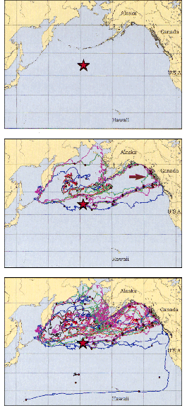
Jim
Ingraham/NOAA/National Marine Fisheries Service (3)In 1992 a container ship spilled 29,000 bath toys into the
Northern Pacific (star, top). After 400 were found (arrow, middle),
oceanographer James Ingraham used a computer model
to track the objects’ route and extrapolate where the remainder would go.
Minor currents would push these floatables along
myriad paths, indicated here by individual colored lines. The center chart
projects the toys’ travels through 1995; the bottom, through the end of last
year. |
x
|
|
|
KAREN
MINOTEach of the oceans is home to one or more huge gyres, formed
by the major surface current systems. These currents, shown above in their
average locations and directions, are driven primarily by prevailing winds
and Earth’s rotation. |
No one knows who found the first Nikes, but McLeod
collected his initial batch of about 20 along and near
Things really got going with the appearance of “Dr. Curt,” as they called him. For him, this was not about the money. It took half
a dozen phone calls to find McLeod, and a dozen or so more brought him to Nike’s transportation manager. The man told him—as Ebbesmeyer suspected—that Nike had lost a load of shoes in a shipping accident;
the courts were ironing it out. “They’re washing up now. Do you want them back?” asked Ebbesmeyer. He was told,
not surprisingly, that he and the beachcombers could keep them. Here, thought Ebbesmeyer, is the best drift experiment anyone could dream
of.
Phoning shipping lawyers, he got court papers with
baseline data: the ship was the Hansa Carrier, en route from
Ebbesmeyer visited the beachcombers repeatedly, and
fit right in. “A kindred spirit—with a PhD!” thought McLeod. He was footloose, so Ebbesmeyer
deputized him to document where more Nikes turned up. On the
Ebbesmeyer’s old
buddy, Jim Ingraham of the U.S. National Oceanic and
Atmospheric Administration, had worked for years to extrapolate a computer
model of changing Pacific surface currents from Navy weather data, but so far
it was only theoretical; here was a real-life test. They plugged in spill
coordinates with beaching coordinates and dates; the predictions of Ingraham’s Ocean
Surface Current Simulator (OSCURS) matched nicely. This allowed Ingraham to refine OSCURS, and draw computer-animated Nike
paths, spreading like ganglia in the ocean and balling up in coastal currents.
Then, based on historical weather data, they simulated identical spills for May
27 of every year, 1946 to 1991. The Nikes went a different way each time—a tribute to the ocean’s variability. “The surface layer is a strange place,” said Ingraham.
Even before it was published in the geophysical journal Eos, the study made them minor media stars (what reporter
could resist science based on oceangoing sneakers?), and with this, Ebbesmeyer found his true calling. Hundreds of people
phoned to see if he could advise on other odd floatables
they had found. Failing to find even one other scientist pursuing such things,
he decided he was the man for the job. He had already cut his paid workweek 40
percent in order to write more; now he awaited his fondest hope: another big
container spill. Besides McLeod, his occasional unpaid “research assistants” included Barry Tweed, a retired Oregon contractor who had built two
stunning seaside houses of cedar, hemlock and redwood logs salvaged from surf;
John Anderson, a Forks, Washington, plumber who had back-packed 30,000
drift-net floats from beaches to a very large pile by his garage; and Vern
Krause, a Washington school bus driver with the distinction of having found a
mysterious stainless-steel sphere that was confiscated by the military after Ebbesmeyer sought help in identifying it. (Deemed safe, it
was returned the next week.)
In December 1991 a friend sent Ebbesmeyer
a message in a bottle found on southern
In 1993 an article from the
Ebbesmeyer confirmed some 400 sightings along 530
miles of
Ebbesmeyer also noted that some of the salvaged toys
appeared to have been gnawed by sea otters, so he drilled otter-tooth-size
holes in his samples to judge what portion of the originals might have sunk:
none. “Very high-quality bathtub toys,’ said Ebbesmeyer. “Buoyant even when half-waterlogged.” He stuck them in his freezer to see if Arctic cold would
crack them. Nope.
Then one day he got a call from a minor shipping
executive, telling him his ship had come in and directing him to a
He has since founded the nonprofit Beachcombers’ and Oceanographers’ International Association, complete with the Beachcombers’ Alert! newsletter (500 paid subscribers
from as far as West Africa and
Aiming to census marine trash in general, in summer 1999
Steve McLeod signed onto a small sailing vessel owned by the environmentalist Algalita Marine Research Foundation for three weeks. They
headed into one eye of the North Pacific Subtropical Gyre—dubbed the Garbage Patch, because it collects so much junk.
McLeod spent the three weeks seasick despite his years in the Coast Guard—but still scanning the horizon. About as far from land as
one can get, they found piles of rope, fishing gear, liquid containers, a
volleyball, even a refrigerator. The main haul was nurdles:
drags with fine nets indicated 129,000 per square mile—six times the mass of collected zooplankton. A mahimahi caught for dinner was full of nurdles.
Ebbesmeyer felt sick when he heard the results. “How do we measure the sea’s wildness?” he said. “Like a doctor sizing up a patient, I’d look her in the face. She’s breaking out in a nasty rash.”
Lately he can be found in his basement warren of six rooms
crammed floor to ceiling with newspapers, books and blue loose-leaf binders
marked by topic, all related somehow to floating things. I visited him there
and saw he was continuing to expand: there were rare books on funerary
practices of the ancient Vikings, who liked setting dead people drift. One
binder read CUBAN REFUGEE RAFTS. A recent subject of speculation, as reported
in Beachcombers’ Alert!: Did the shipwrecked Cuban boy Elián
González survive because porpoises, supposedly
attracted to the floatable inner tube, had nudged the boy to safety?
Next day I visited John Anderson, the plumber with the
major fishing-float collection.
Down in
On my travels I also did a lot of beachcombing myself. My
best site was the Willapa National Wildlife Refuge at
Here, in addition to countless plastic bags, bottle tops,
and soda and water bottles, I logged 302 items. Partial list: beer cans—Coors, Bud, Miller, Hamm’s Rainier; plastic Kodiak chewing tobacco tin; blue plastic 55-gallon
drum, empty; blue plastic hospital ID bracelet, no name; peppermint Life Saver,
individually wrapped; glass Oso Negro liquor bottle,
top on; two foam fishing buoys; plastic deli clamshell; three car tires; Taco
Bell bag; synthetic rope; 12 spent shotgun shells; intact fluorescent light
tube; plastic containers for Windex, Spic & Span, Pennzoil, Dannon and Yami yogurts, Darigold cottage cheese, L’Oreal Kids shampoo; a sneaker made in Taiwan; red-billed cotton cap; two
nice scallop shells; a golf-ball-size chunk of light gray pumice, possibly from
Mount Saint Helens; and—beginner’s luck—a real live message in a bottle.
It was a semitransparent white plastic vitamin bottle with
a rusted metal cap, half buried in fresh, wet sand, displaying a paper square
jammed inside. I unscrewed it and pulled out two dry sheets—a photocopied memorandum dated Oct. 20, 1999, regarding
lifeboats abroad the USS Camden. There was an informal Q&A regarding life, and its alternative,
after abandoning ship for the boats.
Q: After you are in the water, what is the most likely
cause of injury to be encountered?
A: Underwater explosion.
Q: How do you enter the water and proceed away from the
ship in case of burning petroleum in the water?
A: Enter feet first, swim under water, coming to the
surface for air by splashing water away from your head on the way up, go under
again and swim under the water, repeating the process until you are clear of
the flame.
Q: With water, how long could a man survive without food?
A: Three weeks or longer.
Q: How long could a man survive without water?
A: Eight to twelve days.
And so on.
I checked with the Navy. The
![]()
Kevin Krajick’s Barren Lands: An Epic Search for Diamonds in the North American Arctic was
published in October 2001 by W.H. Freeman.
IV 2003 Coastal Upwelling in East
|
|
|


Description:
During the month of July, 2003 there was a prolonged period of upwelling along
the east central
Past Events:
A cursory review of surf temperature data back through 1992 shows that this
event has been much more prolonged than in other years. The year with the next
most prolonged and intense event was 1994. In 2000, there was also an extended
period of cool surf temperatures at
Upwelling Theory:
The reason upwelling occurs is because of Ekman
transport. The flow of most surface currents in the oceans is driven by wind.
When wind blows over water, the surface of that water is not pushed directly in
front of the wind, but moves at about 45 degrees to the right of the wind's
motion in the Northern Hemisphere because of the Coriolis
force (which is caused by the rotation of the earth). As one descends in the
water, the direction of flow continues to be deflected to the right, until
ultimately a three-dimensional spiral is formed vertically in the water. The
net transport of water, as explained by Ekman
transport, is at an angle of roughly 90 degrees to the direction of the wind.
In short, a layer of water near the surface is pulled directly away from the
coast - causing cooler deep water to rise and replace it near the shore.
Reason for 2003 Event:
This year has been so extreme because of the strength and persistence of the
subtropical high pressure ridge. Surface pressures in the
Ramifications/Proposed Theory:
With cooler sea surface temperatures near shore, the east coast sea breeze
should be be stronger than
normal at times. This most likely will lead to a more vigorous Atlantic/Gulf
sea breeze boundary collision and enhance the strength of storms. I think that
the wet season in 1994 also had a lot of severe weather.
Randy Lascody
National Weather Service
Melbourne, FL
Aug. 1, 2003
5.2 . OCEAN NOTES
FRICTIONAL FORCES READING
1. What stress and in which direction does wind
exert on the ocean surface?
2. What direction is the surface water directed by the wind in the
Northern hemisphere/southern hemisphere...what force is responsible for this?
3. How does the faster moving current interact
with the slower moving ones?
4. How much stress would wind of 10mph exert on
water?
5. What is the difference between upwelling and downwelling?
6. Where are some upwelling zones and why are
they important?
7. How productive are downwelling zones?
Why? Name a downwelling
zone.
8. What is the Sverdrup transport?
9. What happens to water temperature as the depth
increases above the thermocline?
10. What happens to water temperature as the
depth increases below the thermocline?
5,3 UPWELLING
Questions
1.
What is upwelling?
2.
What does it do to the ocean and how does this effect productivity?
3. What effect causes this deflection of the
water currents?
4.
Where are major upwelling areas on earth?
5. What causes downwelling?
6.
How does this effect deep waters?
7. How is productivity of