Ocean
Floor First Readings
1. Up Close and Personal On
the Ocean’s Floor
Marine biologists take up residence
4/1989
By PhillipliJ. Hilts
The new $5.5 million facility, owned by the
National Oceanic and Atmospheric Administration and operated in the U.S. Virgin
Islands by
Under water, the barrier to science is not
distance but time. Without such underwater habitats, marine biologists can only
hook their objects of study and drag them out of the water, unable or more than
a few minutes at a time to watch the animals where they live. Even with scuba
gear, researchers have only 15 minutes at 120 feet before they must surface to
avoid getting the bends, the curse of divers that makes the blood ‘boil’ as
gases forced into it by the pressure bubbles out.
Facilities such as Aquarius break the time
barrier, allowing humans to live for days on the ocean bottom— postponing the
long, slow decompression needed to let the gases escape slowly before
surfacing. Time in Aquarius offers an experience still so new, that even
routine trips produce sights and insights that are fresh to human eyes and
minds.
Recently a group of six and students allowed
a reporter to visit several times during their 10-day stay in Aquarius. Their
mission was to study the shaggy, bright walls of coral cliffs rising from the
bottom off the northwestern coast of
Over thousands of years, the corals, quarter
inch long creatures that seem half rock and half animal, have built vast
limestone reefs that protect islands and seashores around the world. Their cathedral like lattices serve as spawning grounds for many
important fish, and ultimately, when buried, coral becomes the source of much
of the world’s oil.
In recent years, corals have become a trove
of potent drugs and chemicals. Now, researchers suspect, they also may provide
crucial clues to the state of global climate change.
In many ways, corals are the undersea
equivalent of the canaries that miners used to take with them below the earth
to detect traces of poisonous gas. When
the sensitive birds died, the miners knew it was time to get out of the mine.
Similarly, coral reefs are so sensitive to changes in light and temperature that they may be
among the first biological systems to change, or to collapse, if the world
warms and the seas rise over the next 50 years, as the "greenhouse effect"
theory predicts.
Currently one of the chief mysteries of
reefs is the widespread death of corals and other reef animals. In the past five years, massive die-offs have
swept across the
Ninety eight percent of the entire population
of black urchins died in one season. Few are left here at
It remains unclear
whether the dieoffs are connected to a global
greenhouse warming, but the possibility has spurred Aquarius biologists to
undertake a wide range of basic studies of coral reef ecosystems. According to
Richard Rounds of Fairleigh Dickinson, it was only
recently that researchers began collecting as basic a form of data as water
temperature.
In life and color, the reefs are as
prolific as any acreage on Earth. They are packed with an estimated million
species, the whole swarming community creating and burning up energy at a
furious rate. Wherever corals can gain a foothold, they build. Their skeletons,
instead of being inside their bodies, are on the outside—bony apartments in
which they live. The shapes of these apartment complexes are strange and
varied, and their names describe them: brain coral as a dome with grooves, the
Elkhorn stands like broad antlers, the sea fan is a great lacy leaf and the deadman's fingers reach up from the bottom and undulate
like a grasping hand.
But there is no margin in this life. The
corals live at their upper limit of temperature; a warming of 2 degrees
can kill them all. They soak up light
hungrily, but a little extra light, as might fall on them if ozone layer decays
enough, can scorch them. And if the sea
level rises only slightly faster than it does now, the slow building reef will be unable to
keep up. It will slowly die from lack of light. Leading scientific
team on Aquarius was Drew Harvell, a
Twice each
day, the divers launched themselves from under the habitat to carry out their
experiments, donning double air tanks and swimming among the unearthly shapes
and colors of the corals, fish, anemones and worms. They also went out on five (nights,
gliding through the water with lights to make
observations.
"Until a few years ago, ecologists
had no information about chemical effects in the ocean. Now we realize that
they have more effect than any other single phenomenon in marine says William Fenical of Scripps Institution of Oceanography, who waited
ashore to analyze coral specimens.
From the point of view of small creatures
such as reef fish, the apparently placid coral reef on which they depend for
sustenance is alive and threatening. "Imagine‘ a Landscape of white rock pockmarked with thousands of
holes,’ wrote Eugene Kaplan in his book, “Coral Reefs." "At night, out of each hole extends a
hand… . . . writhing and snapping at anything that passes by…. Visualize
the hands covered with hair. To touch these hairs could mean instant death, for
some are poisonous."
In the key experiments, divers collected two
species of soft coral from shallow reefs and from reefs 100 feet deep. They
transplanted them—shallow to deep and deep to shallow—into little artificial colonies.colonies.
The experiment is aimed at understanding the
puzzling defense mechanisms of soft corals. They l stand upright,
prominently displayed on the reef, seemingly a choice morsel (passing
predators. Unlike hard corals, they have no stony armor, no piercing projectiles, no nasty barbs. But fish will not go near them. The reason
may be important to medicine as well as to science: The corals produce an array of noxious compounds
to defend themselves.
Biologists want to know whether the
production of toxins is fixed at a given rate by evolution or can vary
according to environmental factors. If
the chemical production is limited by genes, the corals should not be able to
adapt when transplanted to a different environment, such as deeper or shallower
water. If, on the other hand, the production is not fixed the animals should be able
to adapt. For example, corals that produce few toxins in deep water, where
there are few predators, should begin producing the chemicals when moved to
shallow waters where fish start nibbling at them. The transplanted corals will
rest in the canyon off
The scientists did not have to wait for
results of experiment. One night, the team went out with mesh bags to find
banded butterfly fish. The fish were unprepared for night visitors, and the
researchers found that they could stun them simply by shining a light in their
eyes. Back near the Aquarius, Nowlis put each
butterfly fish into a 4by4 foot wire cage with some soft corals. What he saw
was fascinating: The fish avoided eating soft corals, preferring nearly
anything else. But if given nothing else, they nibbled on the less noxious ones
from deeper reefs.
Nowlis other
predators— in one cage the orange and black flamingo tongue, in another the
bristly red and white fire worm. They too chewed up the deep water corals and
avoided the shallow water ones.,
Even Aquarius
cannot give the divers enough time underwater to watch as the natural of a
coral reef unfolds. The corals reproduce only every few years, and then only
for few hours. In one night,
four days after the full moon, they commit their free-swimming larvae to the
sea, to seek their own way. The next time the corals reproduce, Drew Harvell be there to
watch, to collect, to study the young and how they join the life of the coral
reef.
Coral
in Hot Water?
5/1989 Star Bulletin
By Jan TenBruggencate
If the warming
continues, it probably will result in a decline in marine life in Hawaiian
waters, the researcher said.
The
temperature sensitive corals could also be an indicator of the larger potential
environmental problem said Paul L. Jokki, a coral
researcher at the Hawaii Institute of Marine Biology.
Scientists have found that
overly warm water is a primary cause of “bleaching” and sometimes the
subsequent death of coral communities.
s, And they have
noted more and more of these bleachings in
Jokiel and co author L. Coles, with
the King University of Petroleum and Minerals Research
I in
The death of reef coral is a concern
for a variety of reasons, including the protection such reefs provide to the
shoreline. But coral death may be even more important as an indicator of the
health of the marine community, Jokiel said.
Studies show that there tends to he more marine life from shellfish to swimming fish, in
areas with healthy coral communities than in areas with unhealthy or dead
coral, Jokiel said. The reduction in both the
diversity of species and the overall weight of the living things in a given
area may be related to the decline in corals as members of the food chain and
as shelter. But more, the other species decline for the same reasons that cause
the coral to die off, he said.
Corals are long lived
and require a high water quality, If the corals are
going because of changing water conditions, you can assume other species are
impacted also,” he said.
Jokiel did his initial studies in the late 1960's and
early 1970's on the effects of heated water on coral communities in the hot
water outfalls of electrical power plants.
Much of the work was done on the reefs off the Kahe
Point plant on
Then, 1O years
ago,
Jokiel said there is still not sufficient
information to link the higher water temperature greenhouse effect. Most
scientists agree the global warming of the greenhouse effect is coming but they
disagree over whether odd worldwide weather patterns and heat of the past few
years mean it’s already here. Still, a “prolonged warming trend of this
intensity and duration is unprecedented in the long term record,” Jokiel said in their article for “Coral Reefs’ “
"In 1986,
1987 and 1988 Hawaiian corals were perilously close to their bleaching
threshold during the summer months, and localized bleaching did occur, " he said.
Bleaching occurred in some shallow reef areas, but also in waters
as much as 60 feet deep the lee sides of the larger islands: off Olowalu,
Maui, and
“What we’ve had in
But Jokiel said
“Repeated
annual summer bleaching of corals in the thermal (power plume) off Kahe Point did not appear to enhance their thermal
resistance. The same corals continued to bleach every summer, suggesting that
much longer times are needed for adaptation.
. “The possible
rate of warming due to the greenhouse affect would probably occur in less than
50 years, a time frame that appears to be too short for genetic selection in
long-lived reef corals,” the authors wrote in the for “Coral Reefs."
R Jokiel said the
studies of the same species of coral in
Studies of related corals in
Coral bleaching doesn’t only happen because
of heated water. Ultraviolet radiationrcan cause it, as can darkness and lower
salinity in water. But temperature
appears to be the cause of recent reports of bleaching off
.2.
Antarctic Meltdown
At
Shackleton Camp just 300 miles from the South Pole,
it is hard to imagine
The
If there was a major meltdown during
the Pliocene, it could happen again. Antarctica, which is almost twice the size
of
So, are we headed for Waterworld ? Should we build
our homes in stilts? Scientists are divided on this issue. Once camp, the
“dynamists”, believes that the Antarctic ice sheet is dynamic: It has undergone
rapid changes in the past and could do it again. The other camp, the “stablists”, believes that the Antarctic ice sheet is stable
and unlikely to melt away in the foreseeable future. To see what evidence is
being gathered to settle the debate. I flew south last year to visit members of
the two factions during their field seasons.
Getting to Antarctica requires an
eight-hour flight to
After landing a McMurdo, I took a
second flight to Shackleton Camp where the dynamists team had been working for the
past two months.Stiff from the long, cold ride, I
stood up stretched, and looked through the window for any sign of life in this
foreboding, desolate land. I saw six Quonset huts, a handful of tents, and
three outhouses perched on a slab of ice in the middle of a mountain valley. Once outside, my parka rippling against the freezing wind. I
tried to imagine a land that the dynamists say once looked like the green
fjords of
It all began in 1983 when Peter
Webb, a geologist at
This
suggested that the climate during the Pliocene may have been warm enough to
melt the ice and allow the ocean that surrounds
At first the findings were
dismissed. The few scientists who gave them any thought said that the diatoms
must have somehow blown into the sediment from the sea floor. It was a fluke,
they said.
Back in 1983, it was generally
agreed that after
But in 1985, Webb and Harwood
visited
Three years later, beetle remains
turned up in the rubble. With this find, Harwood and Webb's notion of a dynamic
ice sheet and climatic shifts finally grabbed the interest of a cadre of
experts. "The survival of a bettle during the
Pliocene in Antarctica implies that temperatures were significantly warmer than
present," say micropaleontologist Allan Ashworth
of
In the field season that ended in
1996, Harwood and Webb took further steps to investigate their theory. First,
they revisited the
It will take several years to
analyze diatom populations. In the meantime, Harwood and his team are puzzling
over a mosslike plant colony found at Bennett
platform. Harwood says it probably grew in wetlands that were eventually
covered by silt from a nearby river or stream during a glacial advance. The
geology of the area, which is part of the Sirius Group, suggests that a lot of
water was present when the rock face formed.
Ashworth also made a fascinating
discovery: He found seeds and sea shells in the box of rocks he brought back
from the field last year. "They're interesting in their right," he
says, because neither fossil group had previously been found on
Meanwhile, a variety of other
research has beguin to yield supportive evidence. One
study suggests that warm-blooded sea creatures, including dolphins, may have
migrated closer to
"The evidence is quite
compelling," says paleontologist Brian Huber of the Smithsonian's
As I flew by helicopter over McMurdo
Sound toward the
I land in
Marchant
then strolls over to a sandy mound where he has been digging for ash with a
trowel. He says that he reads the history of climate by examining how rocks
weather, and where they are found. Then, for a chronological framework, he
looks for nearby volcanic ash. Ash, like rocks, can reveal environmental clues
through its content and current condition. And because it is the last thing to
land on the surface of a formation, it can pinpoint a minimum age for the
rocks.
Marchant
and
The team has also mapped 75 ash
deposits, and obtained dates for 50 of them. The samples show that the ash
formed in a cold, dry environment, and remained undisturbed. It was found on
rocks that are unmarked by any massive ice sheet movement.
In addition, geologist David Sugden of the
Taken together, these results speak
volumes in favor of a dry, cold, steady state. They indicate that the Pliocene
temperatures were only three to eight degrees Celsius above today's
temperatures, and that the ice sheet covering the
"We do not deny that Harwood is
finding the fossils," says Marchant. In fact, he
says, "we'd expect it." Before Antarctica split from Gondwana, it supported many of the same plants and insects
that are now found in South America and
While Harwood and Webb contend that
their miniature forest withered three million years ago,
For now, the argument remains
unsettled. Though Harwoods says that both camps may
eventually prove to be correct--that there was a long period of cold punctuated
by relatively short bursts of heat--Marchant
disagrees, say "these are mutually exclusive positions and there is no
evidence for an intermediate theory."
About the only thing both camps
agree on is that the key to solving this mystery is to establish, once and for
all, the age of the Sirius sediment fossils. Although this
will be difficult, because there is no definitive technology on which to rely,
an attempt will be amde this year. An
independent group of researchers will drill a core from the Sirius Group rocks
to determine whether diatoms exist below the surface (and therefore are
unlikely to have been windblown), or only near cracks or at the top.
Both groups recognize the urgency of
coming to a firm conclusion. The
Antarctic ice sheet affects only only global sea
level, but also world climate. So agreement on a clear picture of the past
could help to cast a more accurate vision of Earth's future. If the stablists are correct, and the eastern ice sheet remained
frozen during the Pliocene, then there is little reason to worry about the fate
of our coastal cities. A major temperature increase would be required to have
any effect. But if the dynamists are right, and the ice sheet did melt down,
then a moderate rise in the mercury could one day bring on the floods. For now,
however, the answer lies hidden in
Short
Essays
What about the West?
While
the fate of
There are signs that the west
Antarctic ice sheet is already breaking up. A huge iceberg broke free of the
Larsen ice shelf in 1995. Shortly thereafter, a 40-mile-long crack opened in
the adjoining shelf area. Now, ice streams that flow through the sheet are
behaving erratically.
Last year, Stanly Jacobs of Columbia
University's Lamont Donerty Earth Observatory made
the first oceanographic measurements across a deep channel beneath the leading
edge of Pine Island Glacier.His findings show that
the west Antarctic ice sheet is losing mass to the oceans. But whether this
instability is symptomatic of an impending collapse remains unknown.
To
further study the current state of the west Antarctic ice sheet, and to predict
its future, the National Science Foundation is sponsoring a variety of
Antarctica-based research projects. For example, Cal Tech scientists at
Upstream Bravo Camp are sinking ice strings and digging ice cores to study the
movement of fast flowing ice streams.
They're
also burying seismic monitors in snow fields to listen for "ice
quakes" set off by colliding ice sheets.
How Antarctic Ice Affects World Climate
Think of the Antarctic ice sheet as Earth's refrigeration unit: It
exerts a major tw0-way control over today's global environment.
First, the ice sheet (along with a raft of ice that surrounds it
in the southern ocean) reflects back into space about 80 to 85 percent of the
sun that hits it. So icy
Second, the
near-freezing meltwater that runs off the ice cap,
along with the water from melting icebergs, falls to the ocean floor and surges
northward. This surge affects deep-sea circulation, which in turn influences
climate. So, a major meltdown would not only raise sea level worldwide, but
cold also modify weather patterns.
For a better fix
on the details, the National Oceanic and Atmospheric Administration is
monitoring weather, ozone depletion, and long-term climate trends at the South
Pole. In addition, scientists are refining their models of the oceans and the atmsophere by studying bottom water in Antarctica's
July 19,
2002 Posted: 5:28 AM EDT (0928 GMT)
Researchers
surveyed volume and area changes across
From Natalie PawelskiCNN
Sci-Tech
(CNN)
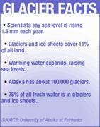
-- A new study indicates that glaciers in
Scientists
have long warned that global warming -- when heat-trapping gases force
atmospheric temperatures to rise -- could eventually raise sea levels to a
dangerous point by melting ice sheets and glaciers.
"The
whole issue of global climate change is important to everyone," said
glacier expert Anthony Arendt of the
Arendt
and his colleagues used a technology called laser altimetry to measure volume
changes of 67 Alaskan glaciers over four decades.
"Glaciers
in
"We
know that the climate has had to change for that to happen," he said.
"Whether or not these changes in climate are due to human
influences, that's not for us to say, but it's possible that it is
linked to a larger-scale change in global climate caused by human
activity."
A
panel of scientists that regularly reports to the United
Nations on global warming issues has projected that sea level will rise
between three inches and about two-and-a-half feet during this century. But
glaciers melting faster than expected could increase that projection.
The
study found that the Alaskan glaciers were thinning enough to produce a
sea-level rise of about .14 millimeters per year -- melting almost twice as
fast as the
The
survey, published in the journal Science, relied on an airborne laser and a
satellite-based global positioning system to plot the glaciers' altitudes and
calculate their volume. Comparisons were then made with topographic maps from
years before the 1990-technology was developed, to extrapolate melting rates
back to the 1950s.
The
Environmental Protection Agency says the Earth's temperature has risen about 1
degree Fahrenheit during the past 100 years, most likely because of global
warming.
"Human
activities have altered the chemical composition of the atmosphere through the
buildup of greenhouse gases – primarily carbon dioxide, methane, and nitrous
oxide," says a definition posted on the EPA Web site. "The
heat-trapping property of these gases is undisputed although uncertainties
exist about exactly how Earth's climate responds to them."
|
|
Measuring
the meltdown
3
Birth of New
Rising from deep within the earth is a jet of molten rock that
cuts large holes in the Pacific seabed, forming new volcanoes and eventually
whole new islands as well, its brood including Maui and
Now,
scientists have descended in a submersible to probe an episode of explosive
violence at the jet's leading edge accompanying the birth throes of a new
Hawaiian island. Their target, a half
mile down, was the summit of Loihi, which has
suddenly become one of the worlds most active
volcanoes.
"It's
nerve-racking" Dr Alexander Malahoff, the expedition's chief scientist, said of his dives into the
dark, churning waters. "The top of the volcano is a physical wreck."
In July and
August, the site was rocked by thousands of seaquakes, including the strongest ever recorded around
Land was in
fact spared. But Dr. Malahoff and other scientists
who dove to the craggy recesses of the undersea volcano discovered a riot of
landslides, toppled rock formations and a bus-size volcanic boulders strewn
over four or five miles. But this was
not the result of a major eruption. The
turmoil at the volcano's top had collapsed its summit, creating a murky crater
more than a half-mile wide and 1000 feet deep.
This was a
He made three
dives into the volcanic depths in as many days late in Sept. 1996, and the
dives continued through October 1996.
The team is diving in a Pisces submersible, which can carry three people
down a little more than a mile and therefore is limited to exploring the
volcano's summit. The whole seamount
rises almost three miles from the ocean floor.
Dr. Malahoff is a director at the Hawaii Undersea Research Lab
at the
And tricky
currents posed dangers. Waters flowed into the newly formed pit, percolated through the volcano's hot
interior and rushed out over a lip on the volcano's western edge. The scientists had to avoid getting sucked
down by the inrush ton one side and pushed up by the out-rush of the other.
They say the
tumult is part of the volcano's halting upward growth. Lava flows build it up, and avalanches and
collapses and cataclysmic explosions knock it down ‘and widen it,
creating a larger base for the next stage of building, Tens of thousands of
years are expected to pass before the volcano's fiery summit rises above the
waves. The fight is between construction and destruction.” Dr. Malahoff said at the news conference.
Avalanches are
well known to have shaken the steep sides of Loihi,
but no episode this violent has ever before been studied up close. Scientists
say the event sheds important new light on the dynamics of island building as
well as a whole range of environmental issues, like the extent to which
explosive releases of volcanic gases like carbon dioxide may be contributing to the
greenhouse warming of the earth. Such releases, they say, may augment human ones.
And it is
aiding overall studies of the Hawaiian jet, the earth's most dynamic zone of volcanic upheaval. Beneath the big
We think it is
rather large, as much as 200 kilometers in diameter-or about 125 miles, Dr.
James G. Moore, a geologist with the United States Geological Survey in
The great heat
engine within the Earth stirs a sea of hot plastic rock that melts
through the crust in places, with the vast majority of the surface action
taking place in the hidden darkness of the deep sea.
In places, the
interior heat gives birth to jets or plumes of hot material that are stationary
in relation to the deep earth but continuously rise toward the surface. Over
the eons, the Jets pierce plates that move slowly overhead, much as a blowtorch
would melt holes in a steel plate moving by.
The gigantic
plates that make up the earth's crust move over the jets at the rate of a few
centimeters a year, or about as fast as fingernails grow.
As a result of
this SLOW creep, a single jet aver the ages can leave a
Trail of extinct, progressively older volcanoes in the plate
above.
Such a trail
is seen the Pacific, where the Hawaiian hot spot has
formed not only the Loihi
volcano but a chain of extinct ones that run west-ward
across the Pacific plate from
The bend where
the Hawaiian chain turns into the Emperor chain
represents a change of plate motion that occurred about 40 million years
ago.
The volcanic
islands are slowly pared down by landslides
and sink deeper into the sea, usually leaving only the newer ones at the
head of the chain above water — or struggling to break through the waves.
Loihi, which means “long
one” in Hawaiian and is pronounced low-EE-hee, and is an elongated monster 13 miles wide and
25 miles long. The `Pacific sea bed on which it rests isl~3.4 miles down at its lowest point. During eruptions and
outbursts over tens of thousands of years. Loihi
has grown until the volcano is now more than 2.8 miles tall. Its stirrings
are carefully monitored by several government agencies including the National
Oceanic and Atmospheric Administration, an arm of the Commerce Department, and
the United States Geological Survey, which maintains a network of seismometers
on the big island. Seismometers measure faint vibrations in the ground
that tell of distant earthquakes
ear~tLoihi has heaved with seaquakes before, most recently in 1991, but not
like this summers torrent of violence. The quakes prompted Harry Kim, the Civil
Defense director of
Island residents are
used to coping with threats of tidal waves generated by distant earthquakes far
across the ocean, but not local ones.
To better
understand what was happening and, in part, to help develop ways to predict and
warn of future dangers, Dr. Malahoff and his team
dove into the depths.
"Eventually something will happen,"
he said of disasters on land touched by the deep volcano, "
but maybe not in our lifetimes.”
In trying to
unravel the mystery of the deep upheaval, the team early on monitored the violence with microphones suspended from
buoys and detected cracklings that sounded like the flow of deep lava. But submersible probings
of the northern
What the team
did discover, based on a comparison with older observations, was that a huge
part of the volcanoes summit had collapsed in the frenzy of destruction. "Nobody,"“ Dr. Malahoff said. “has ever observed
the formation of these pitcraters.”
The collapse of the summit probably look two
or three days, he said, and its slowness was a godsend.. A quick collapse would have generated.
a huge tsunami, or tidal wave. A likely possibility,
he said, is that he slow collapse was provoked when the hot lava from the
volcano’s interior oozed out of its flanks at a depth somewhere below the
region where the Pisces submersible could explore.
ex’ 1 In the most
dangerous moment of the series of dives, Dr. Malahoff
and two colleagues
ventured down to bottom of the new crater past fractured walls of towering
rocks that were threatening to fall.. Later, at the crater’s bottom 1,000
feet the summit, the anxious team in the submersible, heard the rumble of a
distant landslide.
At the base of
the huge cliff, the team found a big vent belching hot water and clouds of
microbial snow in the area around the vent painted with orange and red—and flapping lettucelike leaves of bacterial slime.
~
Mapping the Ocean Floor4
NOAA 95-68 10/23/95 STUNNING NEW SEAFLOOR MAP RELEASED BY NOAA
"We have known more
about the topography of Venus, Mars, and the Moon than the bottom of our own
oceans - until today," said Dr. Walter Smith of the Commerce Department's
National Oceanic and Atmospheric Administration as he introduced a stunning new
map of ocean floor structures. Using
satellite sensor data recently declassified by the Navy in combination with
data from the European Space Agency, Smith and his colleague, Professor David Sandwell of the Scripps Institution of Oceanography, have
generated a computer model of the seafloor in unprecedented detail. The new
map, which infers seafloor features from changes in the strength of gravity,
provides the first detailed view of ocean floor structures in many remote areas
of the Earth.
Marine geologists have
been mapping the ocean floors for some time but, because of limited quality and
coverage of the available data, they have had to use guesswork. Until now, the
most common method of mapping the seafloor has been acoustic echo sounder
readings taken by ships; only a small fraction of the sea floor has been
charted, and in some remote parts of the oceans there are gaps between charted
areas the size of Kansas. Much of the available data is also low tech, and
inaccurately navigated. Even using the most advanced technologies available
today, it would take over 125 years to chart the ocean basins using acoustic
devices on ships.
The newly declassified
satellite data have a survey track every three miles, and so scientists can be
confident that any feature six miles across will not be missed. Another benefit
of mapping the ocean floor via satellite is that the features detected are
located with great precision. With this data it may be possible to answer
questions like: Is there an uncharted island somewhere where Amelia Earhardt could have landed? Are there uncharted shallow
banks that could be rich with marine life and exploitable by commercial
fishing? (We already know the answer to that one is Yes.)
Are there sedimentary basins that might have petroleum reserves that we haven't
mapped yet?
The data used to generate
the new map was gathered by the U.S. Navy's GEOSAT spacecraft between March 31,
1985, and October 30, 1986. As the satellite orbited the
Earth almost 500 miles up in space, a radar altimeter on board returned
readings of the distance from the satellite to the ocean surface accurate to about
one inch. The radar waves were reflected by the ocean surface and did
not penetrate it, unlike the sound waves of an echosounder,
so that the satellite data yield measurements of the shape of the ocean
surface, not the ocean floor. However, Smith and his colleagues at NOAA and
Scripps have worked out a method for exploring the ocean floors using these
data. They first use the satellite data to find tiny changes in the pull of the
Earth's gravity field, and then use those gravity anomalies to infer the
topography of the ocean floor.
"If I had to choose
one thing as being most revolutionary about this map, I would say it is the
view it gives us of the fracture zones," said Smith. In the process of
seafloor spreading that causes continental drift, scars are made on the ocean
floors called fracture zones that record the history of plate motion. These are
used to reconstruct the ancient positions of the continents. Such knowledge can
be extremely valuable in minerals exploration and in the study of climate
change.
The scientific value of
these data was anticipated even as the satellite was flying, and many people
have worked a long time to get the data declassified. While a senator, Vice
President Gore started a group called the Environmental Task Force, to seek
answers to this question: are there technologies and data sets which, because
of their military value, are classified, but which would have even greater
value to the scientific community and the civilian economy if they could be
released? This release of data set is one result of this exercise.
Although the work to
declassify the data is done, NOAA's work with the
data is really only now beginning, as it is now possible to derive data
products that can be distributed to scientific, educational and commercial
users. The raw data representing the spacecraft's measurement of ocean surface
heights is now available from NOAA's
Cool Science Facts
[
Current technology does not allow us to burrow
through the Earth. The rock and metal
thousands of kilometers below our feet are so inaccessible that they might as
well be on another planet.
Believe it or not, the
Earth's solid iron-nickel core helps make life possible. The solid portion of
the metal core spins inside the liquid portion, making the planet act like a
giant generator. The rotation creates the magnetic field which, among other
things, makes compass needles point north and helps create Earth's
magnetosphere. The magnetosphere and the lower atmosphere
work together to protect us from some of the Sun's most dangerous particles.
Every 2,000 - 10,000
years, the Earth's magnetic field reverses. The field leaves a magnetic
"imprint" on crustal rocks, as particles
within the rocks align themselves according to the field. Different layers of
rocks in a formation will have particles aligned differently, depending on the
alignment of the poles when the rocks formed. Many scientists think that the
Earth's poles may reverse again within the next one hundred years. Within your
lifetime, compass needles may point south instead of north. Although this won't
be directly harmful to the human population, it may be confusing for many boy
scouts, not to mention navigators in planes and ships. How do yo u think this event will affect your life? Some birds and
fish use the Earth's magnetic field to navigate their migration. How do you
think they will be affected?
1. How
much did Aquarius cost?
2. How long do divers have to study the bottom
at 120 feet?
3. Why so short a time?
4. What clues are found in the coral?
5. What happened to the black urchin population?
6.
How does "dead man's fingers" get its name?
7. What abiotic
components can kill coral?
8.
What changes on the coral reef at night?
9.
What do corals produce for defense?
10. Which corals did the caged butterfly fish
eat?
11. When do corals reproduce?
CORAL
IN HOT WATER
12. What does warm water do to the corals?
13. Where do these bleachings
occur?
14.
What does the death of reef coral indicate?
15. During which year in
16. Why, with the lower temperature of the waters
of
17. How much higher is the leeching threshold of
18. Besides temperature, what may be causing
coral bleaching?
19.
What is the main idea of this article
2 Antarctic Meltdown by
Beth Livermore Popular Science Feb, ‘97
1.
What percentage of the Antarctic is covered by an ice sheet?
How thick is the ice
sheet?
2. What living organisms have been found on
this ice sheet continent?
3.
When, in the past, could the Antarctic had a temperate
climate?
4.
How is the Antarctic ice sheet divided?
5.
To what structure is the western ice sheet attached?
6.To what structure is the eastern ice sheet attached?
7.
How big is the Antarctic land mass?
8
How much ice and freshwater is there on the continent? 1)
2// 9. What do the "dynamists"
believe?
10.
What do the "stabiists" believe?
11.
What evidence was found that indicated the Antarctic climate was warmer?
12.
What other evidence was found to indicate that the Antarctic was warm in the
last 3 million years?
13.
Where is there no ice or snow in the Antarctic?
14.
Why do we think that the Antarctic was once connected to South America and
15.
What does the Antarctic Ice Sheet affect?
16.
What is the main idea of the
article about the Alaskan Ice
3 “Undersea
Birth Throes of a New Hawaiian
Island
1.
How much lava does the Hawaiian opening(jet) produce
each year?
2.
How long has the “Hawaiian jet” been producing lava ?
3.
What is the name of the new
4.
The new
5.
What happened to “Pete’s Dome’?
6.
How high is this new “ to be” island?
7.
What two volcanoes are powered by the Hawaiian jet?
8.
What is the comparison used in this article about crustal
movement and a common similarity?
9.
How big is Loihi?
10.
Why have recent earthquakes on Loihi caused concern
on the big
11.
What is the main idea of this article
4 SEA FLOOR
MAPPING FROM NOAA 95-68
1.
What does this new map use to map the ocean floor?
2. Why is this a better
method than echosounding?
3. How long will it take to map the sea using echosounding?
4. How small of an area can this new method
pinpoint?
5. Explain how scientists use the radar wave
data?
6. Where is the flattest stretch of solid
surface on earth?
7. What angle do continental slopes usually
reach?
8. How tall is
9. What causes the earth’s magnetic field?
10. What happens to this field (9) every
2,000-10,000 years?
11. How would this (10) effect new layers of
rock?
12.
What is the main idea of this article