Introduction to Physical Oceanography
About 71% of the surface of the planet is covered in salt water. Beneath the depth averages 3,8 km giving it a volume of 1370 x 106 km3. Since life exists throughout this immense volume, the oceans constitute the single largest repository of organisms on the planet. These organisms include representatives of all phylums and are tremendously varied but all are subject to the properties of the sea water that surrounds them and many features common to these plants and animals are the results of adaptations to the watery medium and its movements. Its necessary therefore, to examine the physical and chemical conditions of seawater and aspects of its motion (oceanography) and look at the environment where the organisms live.
The mean depth is 4km and its interconnected from the Arctic to Antarctic. Seawater flows freely among the basins transporting dissolved materials, heat and marine organisms. Seawater mixes from basin to basin/per 1000years but regional characteristics of the seawater do exist.
The major basins are the Pacific, Atlantic, Indian, Arctic, Southern ocean and the boundaries are artificially defined.
Seawater mix
Movement of water moderates world climate by distributing heat from equatorial water to the poles. Warm currents flow toward the poles from the equator (Gulf Stream) heating northern latitudes. Cold water from the Arctic and Antarctic basins flow beneath the oceans surface toward the tropics...cooler water near the equator.
PLATE TECTONICS
There are 8 major plates, up to 100 miles thick and move slowly. They know the direction and speed so can figure out what the continent was like before it moved. The Atlantic has been growing for 150 mil years.
The theory of continental drift or plate tectonics was only established in the 1960's. 200 million years ago, Pangaea fractured and started moving apart 180 mil. yrs ago.
The force that moves the plates over the semi-solid layer of the upper mantle /asthenosphere is the convection currents (large temp. difference between the mantle and crust) and moves plates either 1. apart, 2. together or 3. laterally.
1. apart new material rise as magna /molten rock filling spaces (rifts form mid ocean ridge.
evidence 1965 research vessel Eltanin did magnetic studies
1969 Glomar Challenger did cores from Pacific ant ridge
1977 Project Famous used submersibles
2. Converge one plate dives under another, crumples and forms trenches...usually but not always (mountains) the area is called a seduction zone
Island arcs formed/volcanoes/ from turbulence from the melting of the descending plate.
3. Lateral-sideswipe and cause earthquakes volcanoes and deformations
Mineral deposits in trenches and ridge areas related to tectonic movements.
Geo-sil theory concentration of copper and other metals form as plates melt and separates from crust material, rise in subduction zone near trenches and continues rising until it cools and gets exposed by weathering rocks.
Hydrothermal vents...water percolates into fissures around the rift valley, sinks and heats to 320'C in fissures (pressure) and the heated water dissolves metals and it rises to the seafloor surface, openings flow through the hydrothermal vents, mix with cold water, minerals settle to bottom forming deposits.
Robert Ballard witnessed milky bluish clouds spewing in a Pacific rift zone.
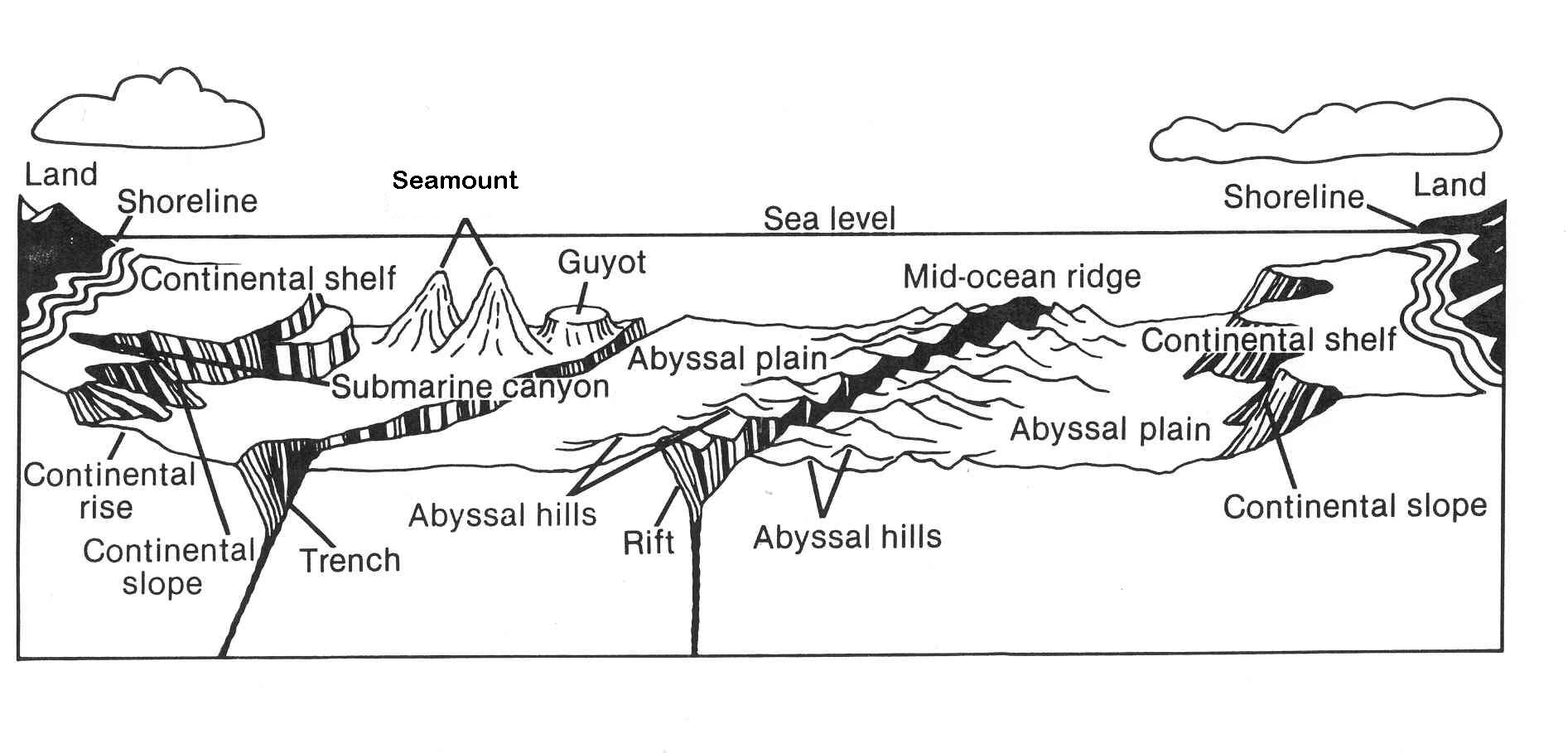
The ocean floor.
Prior to the 1920's, they used weighted rope to probe depths. 1920's the echo sounder (SONAR-(sound navigation and ranging) which analyzed sound waves which bounced off the oceans bottom and returned to the ship. The Meteror (1925-7) did the 1st ocean survey with sonar.
Common topographical features of the oceans include: Continental margin and deep sea as the major divisions.
Continental Margin
Continental shelf-underwater extension of the continental land mass. 8% of the total surface area of the world ocean, yet its one of the most productive parts of the ocean. It gradually drops down to the 100-200m depth.
Continental slope begins where continental shelf plunges down. As the steepness decreases, this zone is called the continental rise.
Underwater canyons occur in the margins which resulted from 1> ocean level was lower with rivers flowing over them eroding the soft sediments making deep gouges. 2. Underwater landslides along the sides of the canyons make the canyon bigger.
profiles of the ocean floors developed from wartime advances and these described patterns of underwater trenches, Mt. ranges and volcanoes along the flat abyssal plane. The idea that the earths crust is composed of movable rigid plates floating on a denser mantle formed.
SEA LEVEL
The sea level has undergone dramatic changes. 15000 years ago 120m below present level. As it fell portions of the continental shelf were exposed changing position of coastline.
Ice age/Wisconsin glacial period, the ocean water froze into glaciers.
Soft sediment of the shelf exposed to erosion from rivers and hen the glaciers started to melt, excess water cut canyons into the shelf. Ocean refilled, flooding shelf and forming underwater canyons. The rise slowed 3000 years ago and has only risen 10m since. It is still rising.
CO2 warming and will flood in next 1000 years.. Green House effect.
Worksheets
1. How long has the “Hawaiian jet” been producing lava ?
2. What is the name of the new Hawaiian Island, not yet above the water line?
3. How high is this new “ to be” island?
4. What two volcanoes are powered by the Hawaiian jet?
Water Chemistry Information
Pressure
Air is .1% as dense as water and the ocean pressure is directly proportional to its depth and acts in all directions within the water <- ->^
The atmospheric pressure is 1kg/cm2 (14.7lbs/sq in)= 1 ATM. An increase of 1 atm for each 33' or 10m and at 30m (100') the pressure is 4atm (1atm/10m + 1atm for air). Mariana trench 11,034m (36192')= 1000atm.
This is known as hydrostatic pressure and because of it, many organisms restricted to particular level or depth and those that can go to all areas have evolved adaptations to compensate for the change.
Density
Salt water is 800x greater in density than air (supports big organisms) The density is affected by temperature. As water cools, water molecules move closer, increasing density..2. 4'C max density (1g/cm3) 3. cooler decreases density..ice= .92g/cm3 and is less dense so it floats. Some organisms have glycoprotein in their blood lowering freezing point of their internal fluid.
Temperature: Water has a high heat capacity...ability to resist rapid temperature changes and is transferred by convection. Temperature is the most important physical factor in the marine environment limiting the distribution of ocean life by effecting density, salinity, gas concentration in oceans. There is minimum vertical mixing because warm water (on top) can't replace cold water. The thermocline is a narrow zone between warm surface water and cold bottom water. Temp. effects ectotherms and endotherms.
It also affects the density as does salinity so both salinity and temp. must be considered to work out density. Variation of -2 (28) to +30 (86). Satellites are now used to monitor water temperatures.
Gases
Gases enter the ocean by diffusion from the atmosphere until it reaches saturation level...different for each gas. The most important are O, CO2 and N. Dissolved O2 = aerobic (use O2 and none= anaerobic...used for respiration and corrosion.
O2 makes up 21% of the atmosphere but in the coldest oceans its less than 1% to as much as 9%. O2 comes from photosynthesis in the ocean and this diffuses into the air because water can only hold small amounts of O2. The ocean provides 50% of atmosphere O2. Turbulence increases the amount of O2 that can dissolve in water. Dissolved O2 declines rapidly as depth increases...why?? At the surface as O2 is used, its replaced quickly by photosynthesis and as it deepens, respiration becomes greater than photosynthesis.
Light p63
Used for
photosynthesis by plants with chlorophyll. Much is reflected back
to atmosphere and as wave action increases, more is reflected.
Lots are absorbed by water but 65% of all light is absorbed
within the 1st meter and only 1% gets to 100m. The sunlit area is
the photic zone where 70% of worlds photosynthesis. At the depth
where photosynthesis=rate of respiration its the compensation
depth. Lower area (not sunlit) is the aphotic zone =90% of the
ocean.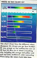
Certain wave lengths are absorbed..blue goes far down and this is vital to photosynthesis as most autotrophs use red and blue light.
Photic zone ranges from 1m in estuaries to 100m in open ocean and depends on turbidity. Turbidity increases along the coast as suspended solids increase. This causes a shift of balance because where blue is the predominant absorbed light in crystal clear water, suspended solids enable wavelengths of green to penetrate deeper than blue in coastal waters. The highly productive water of the coast is greenish and estuaries are brownish. The compensation depth is shallower in coastal waters and below this the autotrophs can't get enough light for photosynthesis to meet the energy requirements.
Seawater Composition
Water...the wonderful stuff held together by hydrogen bonds which causes ice to melt at 0 instead of -90. It causes the absorption of lots of heat to melt ice and same to evaporate water...cooling. It allows water to hold heat...heat capacity and the amount of heat needed to change water temperatures help for cooling of the earth.
Water is a solvent for most substances especially salts. The characteristics of seawater are due to the nature of pure water and the materials dissolved in it. The solids in seawater come from two sources, the chemical weathering of rocks washed to the sea by the rivers and the earth's interior through hydrothermal vents.
Major components of seawater vary slightly. Two processes add salts to the ocean--river discharge and water circulations through hydrothermal vents (hotsprings). All ocean water cycles through these vents every 8-12 million years. These work together making seawater, with the springs adding and removing chemicals.
Salinity is expressed as concentration of ions in a liter of water or # of grams of dissolved solids in 1000g of seawater. Seawater 1000g samples have 34.7g of dissolved matter so salinity is expressed as 34.7 ppt (0/000) or 3.47 % . The remaining 96.5% is pure water. There is a rule of constant proportions and the chloride ions make up 55.27% of however much salt is present in a seawater sample. Also even though organisms may be exposed to changes in salinity...rivers rain etc, they don't have to deal with changes in rations of the various ions dissolved in the seawater. Today they can measure electrical conductivity in conjunction with temperature of water sample..conductivity is proportional to salinity.
Although constant, the concentration can change with addition or removal of water. Different in local areas depending on rate of evaporation/precipitation and volume of fresh water dumped. (red sea=40, Mediterranean=38 lack of rain fall and high evaporation. Black Sea=18 Baltic Sea=8..low evaporation and high runoff.
Euryhaline=organism can tolerate large salinities and fluctuation.
Stenohaline can't tolerate large salinity changes.
Vertical change surface layer mixed..uniform beneath the halocine layer. large salinity changes above..The salinity changes with depth.
Worksheets
<
<